Annapurna Region for Trekking
The Annapurna region, located in north-central Nepal, functions as a premier destination for high-altitude trekking and mountaineering. This diverse geographical zone encompasses the 55-kilometer-long Annapurna Massif, the arid Tibetan plateau of Mustang, and the sub-tropical Pokhara valley. Established trekking trails such as the Annapurna Circuit, Annapurna Base Camp, and the Upper Mustang Trek traverse this landscape. Prominent entities define the terrain, including Annapurna I, Dhaulagiri, and Machhapuchhre. High-altitude passes like Thorong La and Kang La connect the distinct river valleys of the Marsyangdi and Kali Gandaki. The Annapurna Conservation Area Project (ACAP) manages the entire 7,629 square kilometer region to balance tourism and environmental preservation. Restricted zones, specifically Upper Mustang and Nar Phu, require special permits due to their proximity to the Tibetan border.
Trekking Trails in the Annapurna Region
This section details the primary trekking routes established within the Annapurna Conservation Area.
Annapurna Circuit Trek
The Annapurna Circuit Trek encircles the Annapurna Massif. Hikers start in the Marsyangdi Valley and cross the Thorong La Pass at 5,416 meters to reach the Kali Gandaki Gorge. The route traverses distinct climate zones, shifting from sub-tropical forests to an arid high-altitude desert. Road construction has shortened the traditional trail, yet the crossing of Thorong La remains a rigorous high-altitude challenge. The trek connects the districts of Manang and Mustang.
North Annapurna Base Camp Trek
The North Annapurna Base Camp Trek leads to the site of the 1950 French expedition led by Maurice Herzog. The trail begins near Tatopani or Narchyang and ascends the Miristi Khola valley. Trekkers reach the base of the north face of Annapurna I at approximately 4,190 meters. This route sees fewer visitors than the southern sanctuary and offers a raw, wilderness experience. The terrain includes steep ascents through dense bamboo and rhododendron forests.
South Annapurna Base Camp Trek
The South Annapurna Base Camp Trek (ABC) accesses the Annapurna Sanctuary, a glacial basin surrounded by high peaks. The trail follows the Modi Khola valley upstream from Chhomrong. Hikers reach the Base Camp at 4,130 meters, which sits directly beneath the south face of Annapurna I. The route passes through the Machhapuchhre Base Camp, creating a unique double-base-camp experience. Avalanche risk exists on specific sections of the trail during heavy snowfall.
Ghorepani Poon Hill Trek
The Ghorepani Poon Hill Trek functions as a short, lower-altitude acclimatization or panoramic route. The trail loops through the Magar villages of Ulleri and Ghorepani. Hikers ascend Poon Hill at 3,210 meters to view the sunrise over Dhaulagiri and the Annapurna range. Dense rhododendron forests characterize the landscape, particularly during the spring bloom. This route connects easily to the larger Annapurna Base Camp trail.
Nar Phu Valley Trek
The Nar Phu Valley Trek explores a restricted area north of the main Annapurna Circuit. The route splits from the Marsyangdi valley at Koto and enters a narrow, steep-walled canyon. Trekkers visit the remote villages of Nar and Phu, which retain ancient Tibetan culture and architecture. The trail crosses the Kang La Pass at 5,306 meters to rejoin the Annapurna Circuit at Ngawal. This trek requires a restricted area permit and a licensed guide.
Mardi Himal Trek
The Mardi Himal Trek follows a ridge-line route east of the Annapurna Base Camp trail. Hikers ascend from the forest camp to the high camp and finally to the Mardi Himal Base Camp at 4,500 meters. The trail offers close-proximity views of Machhapuchhre (Fishtail) and the Annapurna South face. This route lacks the teahouse density of the main trails, providing a quieter trekking experience. The ridge walk presents sustained views of the Pokhara valley below.
Upper Mustang Trek
The Upper Mustang Trek penetrates the arid rain shadow north of the main Himalayan range. The trail follows the Kali Gandaki river to the walled city of Lo Manthang. Hikers encounter desert landscapes, eroded cliff formations, and ancient cave systems. The region preserves a distinct Tibetan Buddhist culture, separate from the southern valleys. Access requires a high-cost restricted area permit to limit tourist volume.
Dhaulagiri Circuit Trek
The Dhaulagiri Circuit Trek circumvents Mount Dhaulagiri, the seventh-highest peak globally. The trail follows the Myagdi Khola to Dhaulagiri Base Camp at 4,748 meters. Hikers cross French Pass at 5,360 meters and Dhampus Pass at 5,200 meters to access the glaciated Hidden Valley. This rigorous route requires camping logistics and technical glacier travel skills. The itinerary terminates at Marpha, where it merges with the Annapurna Circuit.
Table of Contents
Major Mountains and Peaks
The geological structure of the Annapurna Massif creates a high concentration of 7,000 and 8,000-meter peaks.
Annapurna I
Annapurna I stands at 8,091 meters and ranks as the tenth-highest mountain in the world. Maurice Herzog and Louis Lachenal achieved the first ascent in 1950, marking the first time humans climbed an 8,000-meter peak. The mountain features a massive south face and a technically difficult north face. It remains one of the most dangerous peaks for climbers due to high avalanche risk.
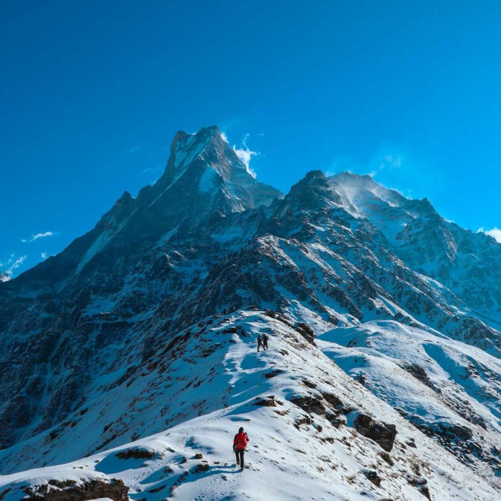
Machhapuchhre
Machhapuchhre, known as “Fishtail,” rises to 6,993 meters. The mountain is sacred to the god Shiva and remains officially unclimbed to preserve its sanctity. Its distinct double-summit spire dominates the skyline of Pokhara and the lower trails. The peak marks the southern boundary of the Annapurna Sanctuary.
Dhaulagiri
Dhaulagiri I reaches 8,167 meters and sits west of the Annapurna Massif. The Kali Gandaki Gorge separates Dhaulagiri from Annapurna I. This mountain forms the western wall of the trekking region and impacts local wind patterns. Its massive bulk is visible from Poon Hill and the Mustang region.
Gangapurna and Annapurna III
Gangapurna (7,455 meters) and Annapurna III (7,555 meters) form a glacial wall above the Manang valley. Glacial melt from Gangapurna feeds the Gangapurna Lake in Manang. These peaks create the northern barrier of the Annapurna Sanctuary and the southern barrier of the Marsyangdi valley.
High Alpine Passes
High passes serve as critical transit points between the distinct river valleys of the region.
Thorong La Pass
Thorong La Pass sits at 5,416 meters and connects the village of Manang to the temple complex of Muktinath. It functions as the highest point on the Annapurna Circuit. Trekkers typically cross from east to west to avoid the steep wind-exposed ascent from the Mustang side. Snow accumulation can block the pass during winter and early spring.
Kang La Pass
Kang La Pass, at 5,306 meters, links the Nar Phu valley with the Manang valley. The pass offers panoramic views of the Annapurna II, III, and Gangapurna north faces. The descent into Ngawal involves a steep scree slope. This pass allows trekkers to loop the Nar Phu region without backtracking.
Mesokanto La Pass
Mesokanto La Pass connects the Tilicho Lake area to Jomsom. This technical pass sits at approximately 5,121 meters. Trekkers use this route as a challenging alternative to Thorong La or to access the hidden lake. The trail requires self-sufficiency as no teahouses exist between Tilicho Base Camp and Jomsom.
National Parks and Conservation Areas
The Annapurna Conservation Area Project (ACAP) pioneered the model of community-based conservation in Nepal.
Annapurna Conservation Area (ACA)
The Annapurna Conservation Area spans 7,629 square kilometers, making it Nepal’s largest protected area. The National Trust for Nature Conservation (NTNC) manages the area. The zone includes land in the Manang, Mustang, Kaski, Myagdi, and Lamjung districts. Regulations within the ACA focus on forest preservation, wildlife protection, and sustainable tourism management.
Conservation Management Zones
ACAP divides the region into land-use zones to balance human activity with nature. Integrated agriculture zones support local farming in lower valleys. Wilderness zones protect high-altitude habitats for snow leopards and blue sheep. Tourism management zones concentrate infrastructure along established trekking routes to limit environmental impact.
Valleys and River Systems
The region’s hydrology shapes the trekking routes and supports the local biodiversity.
Kali Gandaki River System
The Kali Gandaki River flows south between Annapurna and Dhaulagiri, creating the world’s deepest gorge. The riverbed contains ammonite fossils (shaligrams) dating back to the Tethys Sea era. The valley acts as a wind tunnel, generating strong southerly winds daily before noon. This corridor served as a historic salt trade route between Tibet and India.
Marsyangdi River Valley
The Marsyangdi River originates from the northern slopes of Annapurna and flows east. The trekking trail follows this river from Besisahar up to Manang. The valley transitions from V-shaped gorges in the south to a broad, U-shaped glacial valley near Manang. Hydroelectric projects utilize the river’s high-volume flow in the lower sections.
Modi Khola Valley
The Modi Khola drains the Annapurna Sanctuary. The river cuts a narrow, steep valley that provides the only access to the South Annapurna Base Camp. Dense bamboo and rhododendron forests cover the steep valley walls. The river eventually joins the Kali Gandaki further south.
Restricted and Protected Areas
The government designates specific zones as restricted areas to control cultural impact and border security.
Upper Mustang Restricted Area
Upper Mustang constitutes a semi-autonomous region geographically part of the Tibetan plateau. The Department of Immigration issues restricted area permits (RAP) for this zone, costing $500 for the first 10 days. The regulation aims to preserve the fragile Loba culture and the sensitive desert ecosystem. Hikers must travel with a registered guide.
Nar Phu Restricted Area
The Nar and Phu valleys require a specific restricted area permit distinct from the ACA permit. The restriction helps maintain the isolation of the local communities. The permit fee structure varies by season, costing more in the autumn peak season. Checkpoints at Koto enforce these entry regulations.
Key Settlements and Villages
Strategic settlements function as acclimatization hubs and cultural centers for trekkers.
Manang
Manang sits at 3,519 meters in the broad Marsyangdi valley. The village serves as the primary acclimatization stop for trekkers attempting the Thorong La Pass. Gangapurna Lake and the Hundred Rupee Lama’s cave lie nearby. The local economy relies on tourism, agriculture, and trade.
Jomsom
Jomsom functions as the administrative headquarters of the Mustang district. The town houses a STOL (Short Take-Off and Landing) airport that connects the region to Pokhara. Strong winds buffet the town daily in the late morning. It serves as the gateway to both Upper Mustang and the Muktinath pilgrimage site.
Ghandruk
Ghandruk acts as the cultural center for the Gurung people in the Annapurna region. The village features traditional stone-slate houses and offers commanding views of Annapurna South and Machhapuchhre. It serves as a major node on the ACAP trail network, housing the ACAP headquarters visitor center.
Lo Manthang
Lo Manthang stands as the walled capital of the former Kingdom of Lo in Upper Mustang. A six-meter-high wall encircles the settlement. The city contains the royal palace and four major monasteries: Jampa, Thubchen, Chode, and Choprang. The Tiji Festival takes place here annually in the spring.
Muktinath
Muktinath is a sacred pilgrimage site for both Hindus and Buddhists located at 3,710 meters. Hindus call the site Mukti Kshetra (Place of Liberation). The complex features 108 stone water spouts and an eternal natural gas flame. Trekkers visit the temple after crossing Thorong La.
Cultural Heritage and Demographics
The Annapurna region hosts diverse ethnic groups with distinct linguistic and religious traditions.
Gurung and Magar Communities
The Gurung and Magar people inhabit the southern hill regions. They practice a syncretic mix of Buddhism, Hinduism, and animism. These communities traditionally supply soldiers for the Gurkha regiments. Their terraced farms dominate the landscape of the lower trekking trails.
Thakali People
The Thakali people occupy the Kali Gandaki valley, specifically the Thak Khola region. They gained prominence as traders controlling the salt route between Tibet and Nepal. Thakali cuisine dominates the teahouse menus along the Annapurna Circuit. Their architecture features flat roofs and central courtyards adapted to the windy environment.
Loba People of Mustang
The Loba people inhabit Upper Mustang and share close cultural and linguistic ties with Tibet. They practice Sakya Buddhism. The community maintains a traditional social structure centered around the former royal family of Lo. Polyandry was historically practiced to prevent land division.
Flora and Fauna
The extreme altitude variation creates stratified biological zones within the region.
Rhododendron Forests
Rhododendron forests cover the hillsides between 2,000 and 3,000 meters. The Ghorepani and Poon Hill areas host the world’s largest rhododendron species, Rhododendron arboreum. The blooms occur in March and April, turning the hillsides red and pink. These forests provide habitat for langur monkeys and diverse bird species.
Snow Leopard Habitat
The high-altitude deserts of Manang and Mustang support the endangered snow leopard. This apex predator hunts blue sheep (Bharal) on the rocky slopes above the tree line. ACAP monitors the population through camera trapping and community monitoring groups. The snow leopard indicates the health of the alpine ecosystem.
Himalayan Tahr and Blue Sheep
Himalayan Tahr inhabit the steep cliffs of the southern slopes, while Blue Sheep dominate the trans-Himalayan region. Blue Sheep possess the agility to navigate steep scree slopes to evade predators. Trekkers frequently spot herds of Blue Sheep near Manang and on the approach to Thorong La.
Seasonal Climate Patterns
The monsoon and altitude dictate the trekking seasons and visibility conditions.
Pre-Monsoon Season (Spring)
The pre-monsoon season spans from March to May. Temperatures rise progressively, melting winter snow on high passes. Visibility is generally good in the mornings but haze often builds in the afternoons. This season coincides with the blooming of wildflowers and rhododendrons.
Monsoon Season (Summer)
The monsoon brings heavy rain to the southern slopes from June to Early October. The Annapurna Circuit and Base Camp trails experience leeches and obstructed views. However, the Upper Mustang and Nar Phu regions lie in the rain shadow and remain dry. These months function as the primary trekking season for the trans-Himalayan zones.
Post-Monsoon Season (Autumn)
The post-monsoon season runs from late Mid-October to November. The atmosphere clears of dust and moisture, providing the sharpest mountain views. Temperatures remain mild during the day but drop below freezing at night at higher elevations. This period sees the highest volume of trekkers on the Circuit and ABC trails.
Winter Season
Winter lasts from Mid-December to February. Heavy snowfall can close high passes like Thorong La and Kang La. Lodges in higher settlements like Manang often close as owners migrate to lower elevations. Treks in the lower foothills, such as Ghorepani or Mohare Danda, remain accessible.