Everest Region for Trekking
The Everest region, specifically the Khumbu region, constitutes a primary destination for high-altitude trekking in northeastern Nepal. Hikers utilize the Everest Base Camp Trek and the Everest Three Passes Trek to navigate this alpine terrain. Prominent entities define the landscape, including Mount Everest, Lhotse, and Nuptse. High-altitude passes such as Kongma La, Cho La, and Renjo La connect the glacial valleys. Sagarmatha National Park protects the region’s biodiversity and regulates tourism. The Dudh Koshi river system drains the watershed and shapes the valley floors.
Trekking Trails in the Khumbu Region
The following section details the primary trekking routes established within the Sagarmatha zone.
Everest Base Camp Trek
The Everest Base Camp Trek follows a linear route from Lukla to the base of the world’s highest peak. Trekkers ascend through Namche Bazaar to reach an altitude of 5,364 meters at Base Camp. The trail functions as the primary access route for summit expeditions. This itinerary requires acclimatization stops to manage the significant altitude gain.
Everest Three Passes Trek
The Everest Three Passes Trek forms a comprehensive circuit connecting the Chhukung, Gokyo, and Thame valleys. Hikers cross three high-altitude passes: Kongma La, Cho La, and Renjo La. The route demands physical endurance as the trail sustains elevations above 5,000 meters. This trek offers a complete survey of the Sagarmatha National Park interior.
Table of Contents
Major Mountains and Peaks
Mount Everest, standing at 8,848.86 meters, dominates the northern border of the region. Lhotse and Cho Oyu flank the central massif, creating a dense concentration of 8,000-meter peaks. Ama Dablam anchors the central valley skyline with its distinct ridge structure. These geological formations dictate the airflow patterns and local climate of the Khumbu.
High Alpine Passes
Kongma La, Cho La, and Renjo La serve as critical high-altitude connectors between the region’s parallel valleys. These passes exceed 5,300 meters in elevation and often require technical navigation across glacial moraines. Trekkers utilize these crossings to traverse between the Imja and Gokyo valleys without descending to lower elevations.
National Parks and Conservation Areas
Sagarmatha National Park encompasses the entire upper catchment of the Dudh Koshi river. UNESCO designated the park a World Heritage Site in 1979 to protect its unique high-altitude ecosystem. The park authority manages the permit system and enforces regulations to preserve the habitat of the snow leopard and Himalayan tahr.
Valleys and River Systems
The Dudh Koshi river system carves the primary drainage network of the Everest region. Glacial meltwater feeds the Imja Khola, Bhote Koshi, and Dudh Koshi rivers. These fast-flowing water bodies create the deep V-shaped valleys that trekking trails follow during the initial ascent from Lukla.
Key Sherpa Settlements
The Khumbu region contains several permanent Sherpa settlements that function as acclimatization stops and logistical hubs.
Namche Bazaar
Namche Bazaar serves as the commercial and administrative capital of the Khumbu region. The town sits at 3,440 meters and fills a horseshoe-shaped valley. Trekkers utilize Namche for altitude acclimatization before ascending further. The settlement hosts the Sagarmatha National Park Visitor Center and the weekly Saturday market.
Lukla
Lukla functions as the primary entry point for the Everest region. The Tenzing-Hillary Airport occupies a sloping plateau at 2,860 meters. This settlement provides the initial logistical support for expeditions, including porter hiring and supply restocking. Most treks begin and end at this transport hub.
Tengboche
Tengboche village houses the Tengboche Monastery, the largest gompa in the Khumbu region. The settlement sits on a ridge at 3,867 meters, offering panoramic views of Ama Dablam. Mountaineers and trekkers visit the monastery to receive blessings from the Rinpoche. The site hosts the annual Mani Rimdu festival in autumn.
Khumjung and Kunde
Khumjung and Kunde occupy the valley directly above Namche Bazaar. Green roofs characterize the architecture of these twin villages. Sir Edmund Hillary established the Khumjung School and Kunde Hospital here in the 1960s. The villages maintain a more traditional agricultural lifestyle compared to the commercialized trekking routes.
Cultural and Religious Heritage
Tibetan Buddhism shapes the cultural landscape of the Everest region.
Sherpa People
The Sherpa people inhabit the high-altitude valleys of the Solu-Khumbu. They migrated from eastern Tibet approximately 500 years ago. Sherpas dominate the mountaineering industry due to their genetic adaptation to low-oxygen environments. Their economy relies on high-altitude agriculture, trade, and tourism.
Tibetan Buddhism
The Nyingmapa sect of Tibetan Buddhism influences local spiritual practices. Monasteries, chortens, and stupas act as focal points for community life. Monks conduct daily rituals and seasonal festivals to appease local deities. The religion prohibits the killing of animals within the sacred valleys.
Religious Artifacts
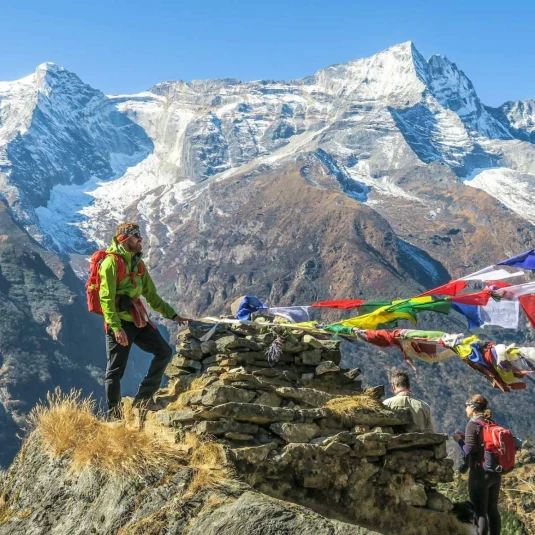
Mani walls and prayer wheels line the trekking trails. Devotees carve Buddhist mantras, such as “Om Mani Padme Hum,” into stone slabs to create Mani walls. Prayer flags connect high passes and summits to spread prayers via the wind. Trekkers must pass these religious structures to the left, in a clockwise direction.
Alpine Flora and Fauna
Sagarmatha National Park protects a distinct high-altitude ecosystem.
Himalayan Wildlife
The region supports endangered species adapted to the alpine environment. The snow leopard functions as the apex predator of the park. Himalayan tahr and musk deer graze on the steep rocky slopes. The Danphe (Himalayan Monal), Nepal’s national bird, inhabits the shrubberies near the timberline.
Vegetation Zones
The vegetation changes drastically with altitude. Pine and hemlock forests dominate the lower elevations near Monjo. Birch and rhododendron forests cover the sub-alpine zone up to 4,000 meters. The landscape shifts to alpine scrub and bare rock above the tree line.
Seasonal Climate Patterns
The regional climate dictates the trekking and climbing schedules.
Pre-Monsoon Season
The pre-monsoon season runs from March to May. Temperatures rise during these months, triggering the rhododendron bloom. This period serves as the primary window for Everest summit attempts due to stable wind conditions. Haze can obscure distant views in the late afternoons.
Post-Monsoon Season
The post-monsoon season occurs from early October to November. This window offers the clearest visibility and sharpest mountain views. Temperatures drop significantly at night, but days remain sunny. Most trekkers choose this season for the Everest Base Camp and Three Passes treks.