Comprehensive Information About Dolpo Region
The Dolpo Region is a high-altitude, culturally Tibetan territory located in the upper Dolpa District of western Nepal. Geologically part of the sedimentary Tibetan-Tethys zone, this trans-Himalayan region spans 5,360 square kilometers, making it the largest district in Nepal by area. The Dhaulagiri massif blocks moisture from the south, creating a semi-arid climate that receives less than 500 millimeters of annual precipitation.
Visitors access this restricted area primarily through Juphal Airport (2,475m), which connects to Nepalgunj in the southern plains. The region operates under a strict permit system, requiring a Restricted Area Permit for Upper Dolpo and a separate permit for Lower Dolpo to control tourism impact. Unlike the lush southern slopes of the Himalayas, Dolpo features barren, windswept valleys, turquoise lakes, and fortified villages that resemble the Tibetan plateau.
The region preserves the ancient Bon Po religion—a pre-Buddhist spiritual tradition—alongside Nyingmapa Buddhism. This cultural isolation, maintained by the high passes that remain snowbound for months, allows communities to sustain traditional agro-pastoral lifestyles known as “samadrok”.
Trekking Trails in Dolpo Region
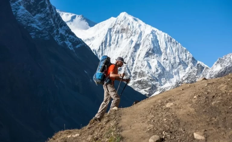
Trekkers navigate the Dolpo region through two primary circuit options: the Lower Dolpo Circuit and the more strenuous Upper Dolpo Circuit.
Lower Dolpo Circuit
The Lower Dolpo Circuit creates a 15 to 18-day loop that connects the administrative headquarters of Dunai with the high-altitude settlements of Dho Tarap and Ringmo.
- Route Structure: Hikers begin at Juphal, follow the Thuli Bheri River to Tarakot, and ascend the Tarap Valley to Dho Tarap (4,090m).
- High Passes: The trail crosses two significant barriers: Numa La Pass (5,318m) and Baga La Pass (5,190m).
- Scenic Highlights: Trekkers witness the deep blue waters of Phoksundo Lake (3,611m) and the thunderous waterfall that drains it.
- Cultural Exposure: This route exposes visitors to the mixed Magar and Tibetan communities of Tarakot before entering the strictly Tibetan-culture zones of the upper valleys.
Upper Dolpo Circuit
The Upper Dolpo Circuit extends the journey to 24 days, pushing north of Phoksundo Lake into the arid landscapes near the Chinese border.
- Route Specifications: This challenging trek requires hikers to cross the Kang La Pass (5,350m) to reach Shey Gompa, the spiritual heart of the region.
- Inner Dolpo Access: The trail traverses the remote villages of Saldang and Yangze, following the ancient salt trade routes used by yak caravans.
- Literature Connection: Trekkers on this route follow the footsteps of Peter Matthiessen, who documented his search for the snow leopard in this specific area in his 1978 book, The Snow Leopard.
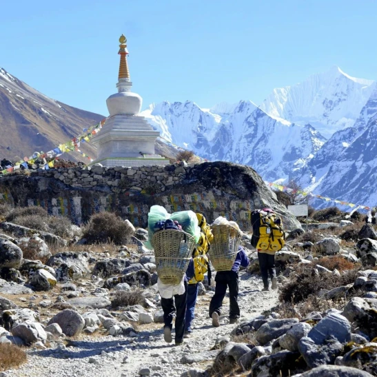
- Logistical Demands: Expeditions must carry full camping supplies and food rations, as teahouse infrastructure beyond Phoksundo and Dho Tarap remains minimal or non-existent.
Beni to Dolpo Traverse
Experienced alpinists connect the Dhaulagiri region to Dolpo via the Beni-Dolpo trail. This arduous route crosses the Entrela Pass into the ‘Hidden Valley’ and descends into the Dolpo region from the southeast. This approach adds significant elevation gain and technical difficulty, suitable only for fully supported expedition teams.
Major Mountains in Dolpo Region
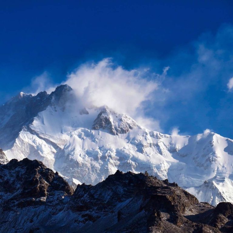
The Dolpo region sits in the rain shadow of the Dhaulagiri massif and contains its own system of high peaks and ridges known as the Kanjirowa Himal.
Kanjirowa Himal (6,883m)
Kanjirowa serves as the highest peak entirely within the Dolpa district.
- Location: The mountain dominates the western skyline of the Phoksundo Lake valley and forms the barrier between the Jagdula and Phoksundo river systems.
- Climbing History: A Japanese expedition team from Osaka City University first summited the peak in 1970.
- Visual Impact: Trekkers view the massive glaciated face of Kanjirowa from the shores of Phoksundo Lake and the summits of the Baga La and Numa La passes.
Crystal Mountain (Shey Ribo)
Crystal Mountain, known locally as Shey Ribo, holds immense spiritual significance despite its modest elevation compared to the 8,000-meter giants.
- Religious Status: Pilgrims regard this peak as the “Younger Brother of Mount Kailash” due to its distinct peak formation and veins of quartz crystal.
- Pilgrimage Circuit: Devotees perform a “kora” (circumambulation) around the mountain during the Tibetan calendar’s Year of the Dragon, believing it purifies a lifetime of negative karma.
- Geological Feature: The mountain contains marine fossils, proving the region was once part of the Tethys Sea floor before the Himalayan uplift.
Putha Hiuchuli (7,246m)
Putha Hiuchuli stands as the westernmost peak of the Dhaulagiri range.
- Ski Mountaineering: Alpinists frequent this peak for ski mountaineering expeditions due to its relatively low angle and consistent snow cover.
- Regional Boundary: The mountain marks the geographical transition between the heavy precipitation zones of the south and the arid rain shadow of Dolpo.
Norbung Kang (6,085m)
Norbung Kang rises near the Kanga La pass, serving as a prominent landmark for trekkers moving between Phoksundo Lake and Shey Gompa. Its snow-capped summit contrasts sharply with the brown, eroded hills of the inner valleys.
Key Villages in Dolpo Region
The settlements of Dolpo operate as high-altitude oases, where stone-walled houses cluster to preserve heat and protect against strong winds.
Dho Tarap (4,080m)
Dho Tarap holds the distinction of being one of the highest permanent human settlements on Earth.
- Economic Hub: This village functions as the primary trade center for the Tarap Valley, where caravans from Tibet historically exchanged salt for grain from the lower hills.
- Demographics: The 180 residents are primarily Khampa Tibetans who maintain close cultural and linguistic ties to the Tibet Autonomous Region.
- Architecture: Villagers build fortress-like stone houses with small windows and flat earthen roofs used for drying crops and storing firewood.
Ringmo (3,641m)
Ringmo sits on a spur directly overlooking the southern end of Shey Phoksundo Lake.
- Bon Culture: The village serves as a stronghold for the Bon Po religion, housing the ancient Tshowa Gompa (900 years old) on the lake’s eastern ridge.
- Conservation Role: Residents actively participate in the buffer zone management of Shey Phoksundo National Park, balancing tourism with environmental protection.
- Livelihood: The community relies on yak herding, small-scale tourism, and the winter trade migration to lower valleys.
Saldang (3,770m)
Saldang acts as the largest settlement in the northern Nankhong Valley, located near the Chinese border.
- Agricultural Base: The village utilizes an extensive irrigation system to grow barley, buckwheat, and potatoes in the arid high-altitude desert.
- Medical Tradition: Saldang is famous for its Amchi tradition, where traditional Tibetan doctors collect and process medicinal herbs for the entire region.
- Strategic Location: The village sits on the main trade route to Tibet, making it wealthier and more developed than neighboring hamlets.
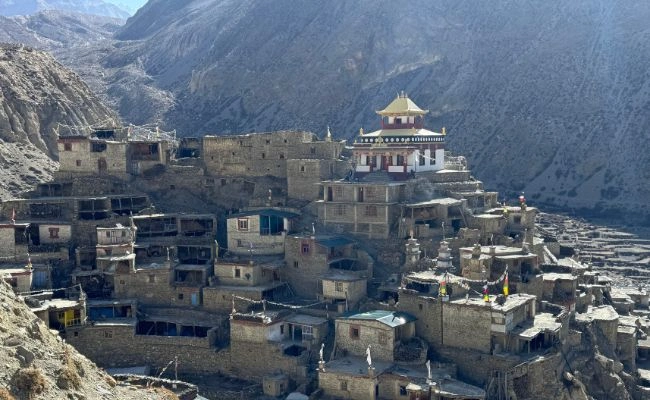
Shey Gompa (4,350m)
Shey Gompa functions less as a village and more as a monastic complex and spiritual sanctuary.
- Historical Significance: Founded in the 11th century, the monastery serves as the spiritual center of Upper Dolpo.
- Isolation: The settlement remains cut off from the rest of the world for nearly six months a year due to snow on the Kang La pass.
- Festival Site: It hosts the Shey Festival every 12 years, drawing thousands of pilgrims from across the Himalayas.
Flora and Fauna in Dolpo Region
The ecological diversity of the Dolpo region falls primarily under the protection of Shey Phoksundo National Park. This 3,555-square-kilometer park serves as Nepal’s largest national park and a vital trans-Himalayan biodiversity hotspot.
Rare Mammals
The high-altitude crags and valleys support some of the world’s most elusive mountain species.
- Snow Leopard (Panthera uncia): Shey Phoksundo National Park contains one of the highest densities of snow leopards in Nepal due to the abundance of blue sheep.
- Blue Sheep (Pseudois nayaur): Herds of blue sheep, or Bharal, graze on the steep, grassy slopes above 4,000 meters, serving as the primary prey for snow leopards.
- Himalayan Musk Deer (Moschus leucogaster): These solitary animals inhabit the birch and rhododendron forests of the lower river valleys, often targeted by poachers for their scent glands.
- Himalayan Wolf (Canis lupus chanco): Genetically distinct Himalayan wolves roam the open steppes of Upper Dolpo, preying on marmots and livestock.
Avian Life
Ornithologists have recorded over 200 bird species within the park boundaries.
- Himalayan Monal (Lophophorus impejanus): Nepal’s national bird, known as the Danfe, displays its iridescent plumage in the subalpine scrublands.
- Cheer Pheasant (Catreus wallichii): This endangered pheasant inhabits the steep, grassy hillsides and faces threats from habitat loss.
- Raptors: Golden eagles and Lammergeiers (bearded vultures) utilize the thermal currents of the deep gorges to patrol for carrion.
Alpine Flora
The vegetation transitions from temperate forests to alpine desert scrub as elevation increases.
- Medicinal Gold (Yarsagumba): The caterpillar fungus (Ophiocordyceps sinensis) grows in the alpine meadows above 4,500 meters. Local communities harvest this high-value fungus in May and June, generating a significant portion of their annual income.
- Caragana and Juniper: In the arid upper valleys, thorny Caragana shrubs and dwarf Juniper trees provide the only ground cover and fuel source for residents.
- Forest Composition: The lower Suligad valley contains dense forests of blue pine, spruce, cypress, and silver fir, creating a habitat distinct from the barren upper highlands.