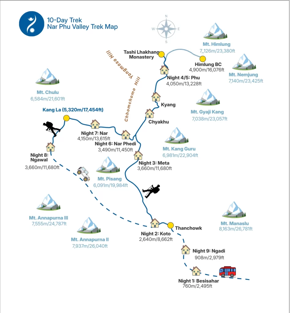
Trekking Map of Nar Phu Valley
The Nar Phu Trek Map is a navigation guide for trekking in Nar Phu Valley, and it includes mountains, villages, hills, base camps, mountain passes, trekking routes, and driving routes within the valley. Only key features of the trek are included to keep the chart clear. The map can be used both by trekkers with map-reading experience and by trekkers with limited map knowledge also.
Nar Phu Trek Map
Nar Phu Valley Trek Map is shown below in a high-quality image format:
| Legend | Meaning |
| Unbroken Solid line | Main Trekking Trail |
| Dashed Line | Driving Route |
| House Icon | Village |
| Yellow Circle | Landmarks (Kang La, Himlung B.C, Monastery) |
The main components of the Nar Phu Valley Trek Map are Kang La (the highest point of the trek), Nar village, Phu village, Koto village, Mount Himlung, Mount Pisang, Mount Kang Guru, and Besisahar town. The map shows the standard Nar Phu trekking route and helps trekkers understand the day-by-day walking stages of the itinerary, as listed below:
| Day | Activities |
|---|---|
| Day 1 |
Drive from Kathmandu to Besisahar
(Full Day Drive: 8-Hour) Endpoint Altitude: 760m/2,495ft Overnight 1: Besisahar town |
| Day 2 |
Drive from Besisahar to Thanchowk and Hike to Koto
(Drive: 4.5-Hour, Hike: 1.5-Hour) Endpoint Altitude: 2,640m/8,662ft Overnight 2: Koto Village |
| Day 3 |
Trek from Koto to Meta
(Trek: 7-Hour, 15.5 Kilometers) Endpoint Altitude: 3,660m/11,680ft Overnight 3: Meta Village |
| Day 4 |
Trek from Meta to Phu
(Trek: 7-Hour, 17.6 Kilometers) Endpoint Altitude: 4,050m/13,288ft Overnight 4: Phu Village |
| Day 5 |
Hike to Himlung Base Camp and Tashi Lhakang Monastery
(Trek: 3-Hour, 7.3 Kilometers) Maximum Altitude: 4,900m/16,076ft Endpoint Altitude: 4,050m/13,288ft Overnight 5: Phu Village |
| Day 6 |
Trek from Phu to Nar Phedi
(Trek: 8-Hour, 16.9 Kilometers) Endpoint Altitude: 3,490m/11,450ft Overnight 6: Thrang Choephel Ling Monastery |
| Day 7 |
Trek from Nar Phedi to Nar
(Trek: 3-Hour, 4.5 Kilometers) Endpoint Altitude: 4,150m/13,615ft Overnight 7: Nar Village |
| Day 8 |
Trek from Nar to Ngawal
(Trek: 9-Hour, 15.18 Kilometers) Maximum Altitude: 5,320m/17,454ft (Kang La) Endpoint Altitude: 3,660m/11,680ft Overnight 8: Ngawal Village |
| Day 9 |
Drive from Ngawal to Ngadi
(Full Day Drive: 6.5-Hour) Endpoint Altitude: 908m/2,979ft Overnight 9: Ngadi village |
| Day 10 |
Drive from Ngadi to Kathmandu
(Full Day Drive: 8-Hour) Endpoint Altitude: 1,300m/4,265ft Trek Ends |
The itinerary table corresponds with the aforementioned Nar Phu Trek map. It allows trekkers to compare the daily itinerary with the map and identify the trails, mountains, and villages encountered on each day of the trek.
Table of Contents
Mountains
The Nar Phu Trek Map includes the following mountains:
- Mount Himlung: Elevation 7,126 m (23,380 ft). Visible from Himlung Base Camp, visited on Day 5.
- Mount Kang Guru: Elevation 6,981 m (22,904 ft). Visible from Nar, Meta, Chyakhu, Nar Phedi, and Kyang villages.
- Mount Pisang: Elevation 6,091 m (19,984 ft). Visible from Chyakhu and Nar Phedi.
- Mount Gyaji Kang: Elevation 7,038 m (23,057 ft). Visible from Himlung Base Camp, Kyang village, and Phu village.
- Mount Nemjung: Elevation 7,140 m (23,425 ft). Visible from Himlung Base Camp.
- Mount Chulu: Elevation 6,584 m (21,601 ft). Visible from Ngawal and Kang La Phedi.
- Mount Annapurna II: Elevation 7,937 m (26,040 ft). Part of the Annapurna Massif. Visible from Kang La and Ngawal.
- Mount Annapurna III: Elevation 7,555 m (24,787 ft). Part of the Annapurna Massif, located west of Annapurna II.
- Mount Manaslu: Elevation 8,163 m (26,781 ft). Visible after Kang La Phedi on Day 8.
The map allows trekkers to locate these mountains in relation to villages and daily trekking sections in the Nar Phu Valley.
Villages and Towns
The villages and towns shown in Nar Phu Valley Trek Map are Nar, Phu, Meta, Chyakhu, Kyang, Ngawal, Ngadi, and Besisahar.
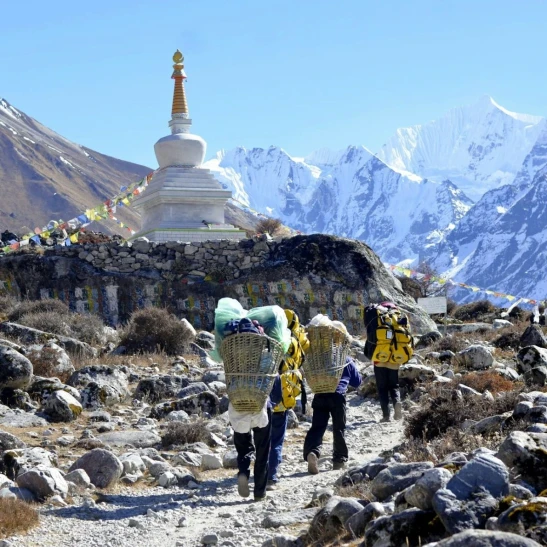
- Nar Village: Nar Village is located in Nar Phu Valley at an altitude of 4,150 m (13,615 ft). Most houses are built using stone and mud.
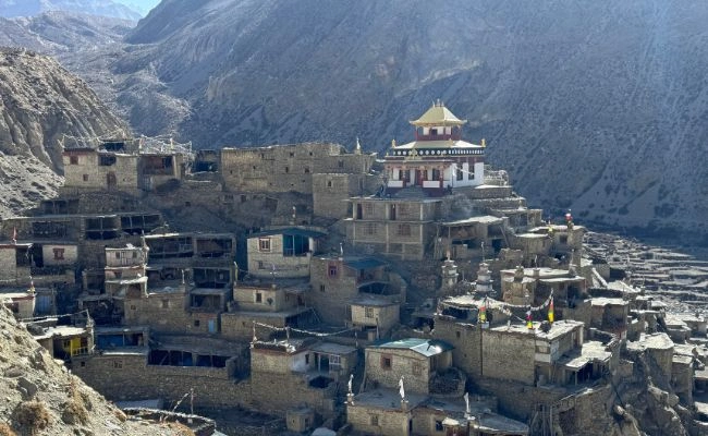
- Phu Village: Phu Village is located in Nar Phu Valley at an altitude of 4,050 m (13,228 ft). The village is situated on a cone-shaped hill. Tashi Lhakhang Monastery is located a few hundred meters from the village.
- Meta Village: Meta Village is located in Nar Phu Valley at an altitude of 3,660 m (11,680 ft). The village developed after trekking routes opened in the area in 2003.
- Chyakhu Village: Chyakhu Village is located at the base of Mount Kang Guru at an altitude of 3,735 m (12,254 ft). Ruins of old stone houses are present in the village.
- Kyang Village: Kyang Village is located at the base of Mount Gyaji Kang and is surrounded by rocky hills. The village lies at an altitude of 3,850 m (12,631 ft).
- Ngawal Village: Ngawal Village lies at an altitude of 3,660 m (11,680 ft). It is the exit point of the Nar Phu Valley Trek after crossing Kang La Pass. Annapurna Massif, Marsyangdi River, Manang Valley, and nearby forests are visible from the area.
- Ngadi Village: Ngadi Village is located in Lamjung District and is not part of Nar Phu Valley. The village lies along the Marsyangdi River. Trekkers stay here on the ninth night of the itinerary.
- Besisahar Town: Besisahar is a town in Lamjung District, and it is not a part of Nar Phu Valley. It is the main entry point to Manang District and the starting location for treks toward the Annapurna region.
Kang La
Kang La, also called Kang La Pass, is a high-altitude mountain pass in the Nar Phu Valley. It connects Nar Village with Ngawal Village and Manang Valley. The pass has an altitude of 5,320 m (17,454 ft). As shown in the above Nar Phu map, trekkers cross Kang La Pass on Day 8 of the trek.
Himlung Base Camp
Himlung Base Camp is a high-altitude base camp at 4,900 m (16,076 ft). It is used by mountaineers preparing to climb Mount Himlung. The area is surrounded by Mount Himlung, Mount Nemjung, and Mount Gyaji Kang. Pangri Glacier is located north of the base camp. It is shown in the top-right section of the map.
Tashi Lhakhang Monastery
Tashi Lhakhang Monastery was built in the 13th century by Lama Karma Sonam Rinpoche. Buddhist pilgrims and monks take a difficult trek to Nar Phu Valley to visit the monastery. On the map, the monastery is shown just east of Phu Village.
Final Words
The Nar Phu Valley Trek Map was simplified based on input from trekking guides. It is designed for trekkers with experience in map reading and for trekkers with limited map-reading skills. The map is intended to be used together with the itinerary to follow the trekking route and identify key mountains and villages. Trekkers can focus on major mountains such as Mount Himlung, Mount Kang Guru, Mount Pisang, and Mount Annapurna II, as well as Nar Village, Phu Village, and Tashi Lhakhang Monastery.