Langtang Region for Trekking
The Langtang region, located directly north of the Kathmandu Valley, constitutes a primary destination for alpine trekking and mountaineering in Nepal. The region borders the Tibet Autonomous Region of China to the north. Trekkers utilize established routes, specifically the Langtang Valley Trek, Gosaikunda Trek, and Tamang Heritage Trek, to navigate the terrain. Prominent entities define the landscape, including the 7,227-meter Langtang Lirung and the sacred Gosaikunda lake system. High-altitude passes, such as Laurebina La and Ganja La, connect the fractured river valleys. Langtang National Park, Nepal’s first Himalayan national park, encompasses the entire trekking zone and protects the habitat of the red panda. The Langtang Khola river system drains the central valley and feeds the Trishuli River.
Trekking Trails in the Langtang Region
This section details the primary trekking routes within the Langtang National Park boundaries.
Langtang Valley Trek
The Langtang Valley Trek follows the Langtang Khola river east from Syabrubesi. Hikers ascend through dense rhododendron forests to the alpine meadows of Kyanjin Gompa at 3,870 meters. The route offers immediate proximity to Langtang Lirung and the Langtang Lirung Glacier. This linear trail serves as the central artery of the region. The valley floor facilitates acclimatization before climbers attempt nearby peaks like Tserko Ri.
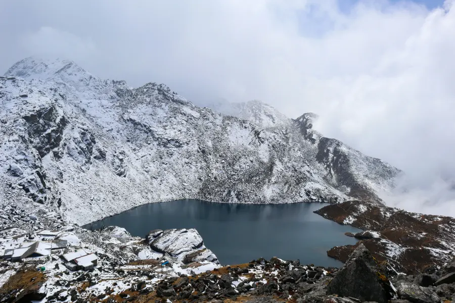
Gosaikunda Trek
The Gosaikunda Trek targets a high-altitude oligotrophic lake system at 4,380 meters. Pilgrims and trekkers ascend steep ridges from Dhunche or traverse from the Langtang Valley. The trail crosses the Laurebina La Pass at 4,610 meters, linking the Nuwakot and Sindhupalchok districts. Hindu devotees visit the lakes during the Janai Purnima festival to worship Lord Shiva. The route provides expansive views of the Manaslu and Ganesh Himal ranges.
Tamang Heritage Trek
The Tamang Heritage Trek circles the western section of the Langtang region near the Tibetan border. This community-based trail connects the traditional villages of Gatlang, Tatopani, and Thuman. The route emphasizes cultural immersion in Tamang settlements rather than high-altitude climbing. Hikers experience distinct Tibetan-influenced architecture and agricultural practices. The trail generally remains below 3,000 meters, making it accessible during colder months.
Major Mountains and Peaks
The geological structure of the Langtang Himal creates a massive barrier of snow-capped peaks along the northern border.
Langtang Lirung
Langtang Lirung stands at 7,227 meters and dominates the skyline of the Langtang Valley. It ranks as the highest peak in the Langtang Himal range. The mountain features a massive vertical relief above the valley floor, creating frequent avalanches on its eastern face. A Japanese expedition team achieved the first ascent in 1978. The peak forms a visual anchor for trekkers throughout the ascent from Ghodatabela to Kyanjin Gompa.
Dorje Lakpa
Dorje Lakpa rises to 6,966 meters at the eastern end of the Langtang region. The mountain exhibits a distinct pyramid shape visible from the Kathmandu Valley. It sits within the Jugal Himal range but connects geographically to the Langtang trekking routes. Climbers and photographers utilize the vantage point of Laurebina La to view its western face.
Langtang Ri
Langtang Ri reaches an elevation of 7,205 meters. The peak lies on the international border between Nepal and Tibet. It sits immediately west of Langtang Lirung. The mountain feeds the complex glacial systems that drain into the upper Langtang Valley. Its proximity to the border requires strict climbing permit regulations.
Yala Peak
Yala Peak stands at 5,500 meters and functions as a popular “trekking peak” for novice mountaineers. The summit offers a non-technical climbing route accessible from Kyanjin Gompa. Climbers use Yala Peak to gain views of Shishapangma (8,027 meters) in Tibet. The ascent requires basic crampon and ice axe skills but does not demand extensive technical experience.
High Alpine Passes
High-altitude passes serve as critical transit corridors between the distinct valleys and districts of the region.
Laurebina La Pass
Laurebina La Pass sits at 4,610 meters on the Gosaikunda Trek. The pass connects the Gosaikunda lake basin with the Helambu region to the southeast. Trekkers crossing this pass transition from the alpine scrub of the Gosaikunda sanctuary to the dense forests of the Melamchi valley. Snow blockage frequently occurs from January to March. The pass provides a panoramic vantage point covering the Annapurna, Manaslu, and Ganesh Himal ranges.
Ganja La Pass
Ganja La Pass, located at 5,130 meters, links the Langtang Valley directly to the Helambu region. This technical pass requires camping equipment and mountaineering skills. The southern descent involves steep rockfall zones and navigational challenges. Trekkers use this route to exit the Langtang Valley without retracing their steps to Syabrubesi. Usage remains low due to the technical difficulty and lack of teahouse infrastructure.
Tilman’s Pass
Tilman’s Pass sits at 5,308 meters and connects the upper Langtang Valley with the Panch Pokhari region. Bill Tilman, a British explorer, discovered the route in 1949. The pass involves crossing high-altitude glaciers and requires full expedition support. Few trekkers attempt this crossing due to its isolation and physical demands. It serves as a historical connector between the Langtang and Jugal Himal ranges.
National
The Langtang National Park manages the biological and geological resources of the region.
Langtang National Park
Langtang National Park, established in 1976, holds the distinction as Nepal’s first Himalayan national park. The protected area spans 1,710 square kilometers across the Nuwakot, Rasuwa, and Sindhupalchok districts. The Department of National Parks and Wildlife Conservation (DNPWC) administers the zone. The park encompasses diverse climatic zones, ranging from subtropical forests at 1,000 meters to alpine deserts above 4,000 meters. A buffer zone surrounds the park to support local community forest management.
Valleys and River Systems
Hydrological systems carve the landscape and dictate the location of settlements and trails.
Langtang Khola Valley
The Langtang Khola river originates from the Langtang Lirung and Shalbachum glaciers. The river cuts a deep, U-shaped glacial valley running east to west. Trekking trails follow the riverbanks from Syabrubesi up to the glacial moraines at Langshisha Kharka. The valley walls rise steeply, trapping moisture and creating lush forest ecosystems in the lower sections. The river merges with the Bhote Koshi at Syabrubesi to form the Upper Trishuli.
Trishuli River System
The Trishuli River drains the entire Langtang and Ganesh Himal watershed. It flows south into the Narayani system and eventually the Ganges. The river supports hydroelectric projects and rafting tourism downstream. Its tributaries, including the Bhote Koshi and Langtang Khola, channel meltwater from the high Himalayas. The road to the trailhead at Dhunche follows the Trishuli river gorge.
Restricted and Protected Areas
Specific zones within the region require additional permits or adhere to strict cultural protections.
Border Proximity Zones
Areas north of the Langtang Valley and near Rasuwagadhi sit close to the Chinese border. While not restricted like Upper Mustang, these zones see heavy security presence. Trekkers cannot cross into Tibet without specific visas and permits. The Rasuwagadhi border crossing serves as a major trade route between Nepal and China.
Sacred Gosaikunda Zone
The Gosaikunda Lake area holds religious significance for Hindus and Buddhists. The Langtang National Park enforces strict waste management rules here to preserve the water quality. Bathing in the lakes is permitted only during specific religious festivals. The area lacks permanent settlements; lodges operate seasonally to support pilgrims and trekkers.
Key Settlements and Villages
The region contains several permanent settlements that function as logistical hubs and cultural centers.
Syabrubesi
Syabrubesi sits at 1,503 meters at the confluence of the Bhote Koshi and Langtang Khola rivers. The town serves as the primary trailhead for the Langtang Valley and Tamang Heritage treks. Roads connect Syabrubesi to Kathmandu, facilitating supply transport. The settlement offers hotels, equipment shops, and bus terminals for trekkers.
Kyanjin Gompa
Kyanjin Gompa functions as the highest permanent settlement in the Langtang Valley at 3,870 meters. The village takes its name from the centuries-old Kyanjin Monastery. Trekkers use this settlement as a base for day hikes to Kyanjin Ri and Tserko Ri. A Swiss-funded cheese factory operates here, utilizing yak milk from the surrounding pastures. The settlement was rebuilt following the 2015 earthquake.
Langtang Village
Langtang Village, the valley’s namesake settlement, lies at approximately 3,430 meters. A massive avalanche triggered by the April 2015 earthquake destroyed the original village. Residents rebuilt the settlement, now called “New Langtang,” slightly east of the original site. The village serves as a major overnight stop for trekkers. Memorial walls and mani stones commemorate the victims of the disaster.
Gatlang
Gatlang is a traditional Tamang village located on the Tamang Heritage Trail. The settlement features clustered stone houses with wooden roofs. The Parvati Kunda lake and an ancient monastery sit above the village. Gatlang preserves the pre-Buddhist Bon practices alongside Tibetan Buddhism. Trekkers stay in community lodges or homestays to observe the local lifestyle.
Dhunche
Dhunche serves as the administrative headquarters of the Rasuwa district. The town sits at 2,030 meters and marks the entry point for the Gosaikunda Trek. The Langtang National Park office issues permits here. Dhunche provides medical facilities, banks, and supplies for trekkers and locals.
Cultural Heritage and Demographics
The region hosts distinct ethnic groups with deep historical ties to Tibet.
Tamang People
The Tamang people constitute the majority population in the Langtang region. Their ancestors migrated from Tibet, and their language belongs to the Tibeto-Burman family. “Tamang” translates roughly to “Horse Warrior.” They practice a form of Buddhism infused with Shamanism (Bon). Their economy relies on agriculture, animal husbandry (yaks and sheep), and tourism.
Tibetan Buddhism
Tibetan Buddhism dominates the spiritual life of the region. Monasteries (Gompas) and Chortens serve as community anchors. The Kyanjin Gompa monastery houses ancient scriptures and statues. Prayer flags flutter on passes and bridges to spread blessings. Local festivals, such as Losar (Tibetan New Year), follow the lunar calendar.
Bon Culture
Elements of the pre-Buddhist Bon religion persist in the Tamang communities. Jhankris (shamans) conduct healing rituals and exorcisms. They act as mediators between the human and spirit worlds. These practices are particularly visible in the villages of the Tamang Heritage Trail.
Flora and Fauna
The region’s biodiversity varies vertically with the altitude.
Rhododendron Forests
Rhododendron forests dominate the sub-alpine zone between 2,000 and 3,000 meters. Rhododendron arboreum, the national flower of Nepal, blooms in red, pink, and white during spring (March-April). These forests provide cover for musk deer and Himalayan black bears. The density of the canopy regulates soil moisture and prevents erosion.
Alpine Scrub and Meadows
Above 4,000 meters, the vegetation transitions to alpine scrub and grasslands. Dwarf junipers and medicinal herbs adapt to the harsh, windy conditions. Yaks graze on these high-altitude pastures during the summer monsoon. The famous “Yarsagumba” (Caterpillar Fungus) grows in these meadows and provides income for local pickers.
Himalayan Tahr
The Himalayan Tahr (Hemitragus jemlahicus) inhabits the steep rocky cliffs of the Langtang valley. These wild goats possess rubbery hooves adapted for gripping rock faces. Trekkers frequently spot herds of Tahr on the slopes near Kyanjin Gompa. They serve as the primary prey for the elusive snow leopard.
Seasonal Climate Patterns
The climate dictates the safety and feasibility of trekking activities.
Spring Season (Pre-Monsoon)
Spring runs from March to May. Temperatures warm up, melting the winter snow on the lower trails. This season offers stable weather for crossing high passes like Ganja La. The blooming rhododendrons attract botanists and photographers. Haze may obscure distant peaks in the afternoons.
Autumn Season (Post-Monsoon)
Autumn spans from late Mid-October to November. The monsoon rains wash dust from the air, creating crystal-clear visibility. This period marks the peak trekking season. Stable high-pressure systems provide predictable weather windows for climbing Yala Peak and Tserko Ri. Nighttime temperatures drop below freezing above 3,500 meters.
Winter Season
Winter lasts from Mid-December to February. Heavy snowfall frequently blocks the Laurebina La and Ganja La passes. Lodges in Kyanjin Gompa may close if snow levels become excessive. Trekkers who visit during this time experience solitude and clear days but face extreme cold. The Tamang Heritage Trail remains accessible due to its lower elevation.
Monsoon Season
The monsoon affects the region from June to Early October. Heavy rains trigger landslides on the roads to Syabrubesi and Dhunche. Leeches infest the lower forest trails. However, the high alpine meadows burst with wildflowers during this wet season. Few trekkers visit during these months due to transport uncertainty and obscured views.