Comprehensive Information About Rolwaling Valley
The Rolwaling Valley is a high-altitude east-west valley situated in the Dolakha District of east-central Nepal, sandwiched between the Langtang and Everest regions. Geographically, the valley lies just south of the Tibetan border and operates as a natural biodiversity corridor within the Gaurishankar Conservation Area (GCAP). Mountaineers and trekkers recognize this region as one of the “beyuls”—hidden valleys designated by Padmasambhava as refuges for Buddhism—which preserves its cultural and ecological sanctity.
The valley extends from the Tama Koshi River in the west to the Tashi Lapcha Pass (5,755m) in the east, effectively separating the Rolwaling Himal from the Khumbu region. Unlike the commercialized trails of the Annapurna or Everest circuits, Rolwaling demands self-sufficiency, as infrastructure beyond the village of Beding remains basic or nonexistent. Visitors must obtain a special Restricted Area Permit (RAP) to enter the upper valley, a regulation that limits foot traffic and helps preserve the fragile alpine ecosystem.
Indigenous Sherpa communities inhabit this rugged terrain, maintaining a transhumance lifestyle that revolves around yak herding and high-altitude agriculture. These communities manage the local resources through the Gaurishankar Conservation Area Management Council, ensuring that tourism benefits directly support local conservation and infrastructure projects. The region gained global scientific attention in the 1950s when explorer Eric Shipton photographed mysterious footprints here, sparking the legend of the Yeti.
Trekking Trails in Rolwaling Valley
Hikers access the Rolwaling interior primarily through two distinct approaches: the moderate Tsho Rolpa Lake trek and the technical Rolwaling-Khumbu traverse via Tashi Lapcha Pass.
Rolwaling Tashi Lapcha Pass Trek
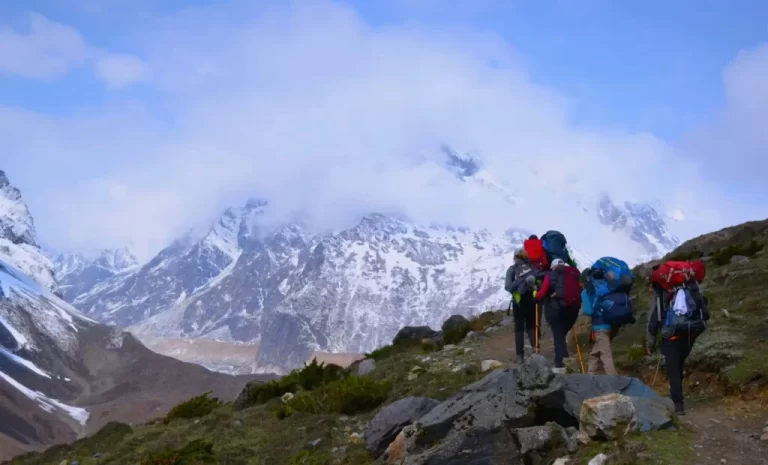
The Tashi Lapcha Pass Trek creates a challenging 18 to 21-day expedition that connects the Rolwaling Valley directly to the Thame Valley in the Everest region.
- Route Structure: Expeditions begin with a drive to Jagat or Gongar Khola (1,150m) and ascend steeply through the terraced fields of Simigaon.
- Technical Challenge: Climbers must navigate the Tashi Lapcha Pass (5,755m), a glaciated saddle that often requires crampons, ropes, and ice axes for safe crossing.
- Glacial Traverse: The trail crosses the unstable Drolambao Glacier and the Trakarding Glacier, presenting rockfall hazards and crevasse risks that demand experienced guides.
- Camping Requirement: Teams must carry full camping logistics for at least three nights between Na village and Thame, as no teahouses exist in this high-altitude “death zone”.
Tsho Rolpa Lake Trek
The Tsho Rolpa Lake Trek offers a moderate 12 to 14-day alternative for trekkers seeking high-altitude scenery without technical mountaineering.
- Destination: Hikers terminate at Tsho Rolpa (4,580m), one of Nepal’s largest glacial lakes, known for its turquoise waters and the hanging glaciers of the Rolwaling massif.
- Acclimatization Focus: The itinerary allows for gradual ascent, with critical rest days in Beding (3,690m) to prevent Acute Mountain Sickness (AMS) before pushing to the lake.
- Return Route: Trekkers typically retrace their steps to Gongar Khola, as the only alternative exit is the technical Tashi Lapcha pass.
Indigenous Peoples Trail
The Indigenous Peoples Trail traverses the lower mid-hills south of the main Rolwaling range, focusing on cultural immersion rather than high-altitude climbing.
- Cultural Scope: Visitors walk through Thami, Tamang, and Sherpa villages, experiencing diverse festivals and shamanistic rituals distinct from the high-altitude Buddhist culture.
- Topography: The path stays primarily below 3,200 meters, winding through broadleaf forests and agricultural terraces, making it accessible year-round.
Major Mountains in Rolwaling Valley
The Rolwaling Himal forms a massive wall of ice and rock that includes over 50 peaks exceeding 6,000 meters.
Mount Gaurishankar (7,134m)
Mount Gaurishankar dominates the western skyline of the valley and holds immense religious and geographical significance.
- Religious Status: Hindus revere the dual summit as the physical manifestation of Lord Shiva (Shankar) and his consort Gauri, prohibiting climbers from standing on the absolute top.
- Time Meridian: The Nepal Standard Time (UTC+05:45) is based on the longitude of this specific mountain, highlighting its central role in national geography.
- Visual Impact: Trekkers view the sheer south face of Gaurishankar directly from the village of Simigaon, where it rises over 5,000 vertical meters from the river valley.
Melungtse (7,181m)
Melungtse stands as the highest peak in the Rolwaling Himal, though its main summit lies just across the border in Tibet.
- Topography: The mountain features a long summit ridge with two distinct high points: Melungtse Main (7,181m) and Melungtse II (7,023m).
- Isolation: The peak remains difficult to view from the lower Rolwaling valley due to the intervening ridges, but it becomes visible from the high passes and the northern glaciated plateaus.
Pachermo Peak (6,273m)
Pachermo Peak rises directly above the Tashi Lapcha Pass, serving as a popular “trekking peak” for fit alpinists.
- Climbing Profile: The ascent involves a straightforward but steep snow plod from the pass, offering panoramic views of Everest, Cho Oyu, and Makalu.
- Permit Requirements: Climbers must obtain a specific peak climbing permit from the Nepal Mountaineering Association (NMA) to attempt this summit legally.
Yalung Ri (5,630m)
Yalung Ri offers a non-technical climbing objective near Na village, suitable for trekkers wishing to exceed 5,500 meters.
- Accessibility: Teams can summit and return to Na in a single day, making it an excellent acclimatization hike before attempting the Tashi Lapcha crossing.
- Vantage Point: The summit provides a 360-degree panorama of the entire upper Rolwaling amphitheater and the glacial systems feeding the Tsho Rolpa lake.
Key Villages in Rolwaling Valley
The human settlements in Rolwaling reflect a deep adaptation to the harsh, high-altitude environment, with villages located strategically to maximize sunlight and agricultural yield.
Beding (3,690m)
Beding functions as the primary permanent settlement and administrative center of the upper Rolwaling Valley.
- Mountaineering Legacy: This single village has produced an exceptionally high number of Everest summiters per capita, earning it a reputation as a hub for elite climbing Sherpas.
- Religious Center: The village hosts the historical Rolwaling Sangag Choling Monastery, carved into a cliffside, which serves as the spiritual heart of the community.
- Infrastructure: Trekkers find the most reliable teahouses, satellite internet, and supply shops here before entering the wilderness zone to the east.
Na Gaon (4,180m)
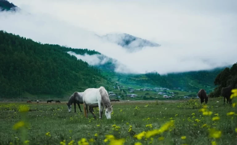
Na Gaon operates as a seasonal summer settlement (yersa) located in a broad U-shaped valley floor surrounded by glacial moraines.
- Agricultural Adaptation: Residents migrate here during the summer monsoon to graze yaks and cultivate fast-growing crops like potatoes and barley.
- Strategic Location: The village sits directly below the Tsho Rolpa lake, making it the final logistical base for expeditions heading toward the Tashi Lapcha pass.
- Climate Reality: During winter, heavy snowfall buries Na, forcing all inhabitants to retreat to Beding or lower altitudes.
Simigaon (2,000m)
Simigaon marks the cultural transition zone where the Hindu-influenced lower hills give way to the Tibetan-Buddhist highlands.
- Terraced Farming: Villagers maintain elaborate terraced fields carved into steep hillsides, growing millet, corn, and vegetables.
- Cultural Mix: The population includes Sherpa and Tamang families, creating a unique blend of architectural styles and religious practices.
- Entry Gate: Hikers typically spend their first night here after the drive from Kathmandu, using the village to adjust to the trail conditions.
Flora and Fauna in Rolwaling Valley
The Rolwaling Valley falls entirely within the Gaurishankar Conservation Area (2,179 sq km), a protected zone established in 2010 to safeguard the region’s vertical biodiversity.
Mammalian Wildlife
The remote, rugged terrain supports populations of elusive Himalayan mammals that have vanished from more developed regions.
- Snow Leopard (Panthera uncia): Conservationists have documented snow leopards patrolling the high rocky ridges above 4,000 meters, preying on blue sheep.
- Red Panda (Ailurus fulgens): The temperate bamboo and oak forests between 2,500 and 3,500 meters harbor the endangered red panda.
- Himalayan Tahr: Herds of these wild goats frequent the steep grassy cliffs near Beding, often visible from the main trekking trail.
- Himalayan Musk Deer: The birch forests provide cover for musk deer, which face threats from poaching for their valuable scent glands.
Avian Species
Ornithologists recognize the valley as an Important Bird Area (IBA) due to its diverse habitats ranging from river valleys to glacial scree.
- Himalayan Monal (Danfe): Nepal’s national bird, the iridescent Danfe, thrives in the subalpine shrublands near Na village.
- Raptors: Golden eagles and Himalayan Griffons utilize the strong thermal currents generated by the deep valley walls to hunt for marmots and small rodents.
Vegetation Zones
The flora changes dramatically with altitude, creating distinct ecological bands.
- Subtropical to Temperate: The lower trail near Gongar Khola features humid forests of Chir pine, alder, and hemlock.
- Subalpine Zone: As the trail ascends to Beding, the forest transitions to dense rhododendron (burans) thickets and silver fir, which bloom in vibrant reds and pinks during spring.
- Alpine Scrub: Above Na, the vegetation dwarfs into juniper scrub and alpine grasses, eventually giving way to the bare rock and ice of the nival zone.
- Medicinal Plants: The high pastures yield valuable medicinal herbs, including Yarsagumba (Ophiocordyceps sinensis), which locals harvest in May and June to supplement their income.
Glacial Lake Management
The ecosystem includes the managed Tsho Rolpa glacial lake, which poses a Glacial Lake Outburst Flood (GLOF) risk to the biodiversity downstream.
- Mitigation Engineering: Engineers constructed a canal and siphon system in 2000 to lower the lake level by 3 meters, reducing the immediate threat to the riverine forests and settlements below.
- Climate Impact: Rising temperatures continue to expand the lake area (increased by 3.3% from 2010 to 2015), altering the local microclimate and threatening the stability of the moraine dam.