Manaslu Circuit Trek 2026 | Itinerary, Map, Price
Inside this guide: Find the Manaslu Trek itinerary, per-person costs, a trek map, details on who the trek is right for, and essential pre-trek information.
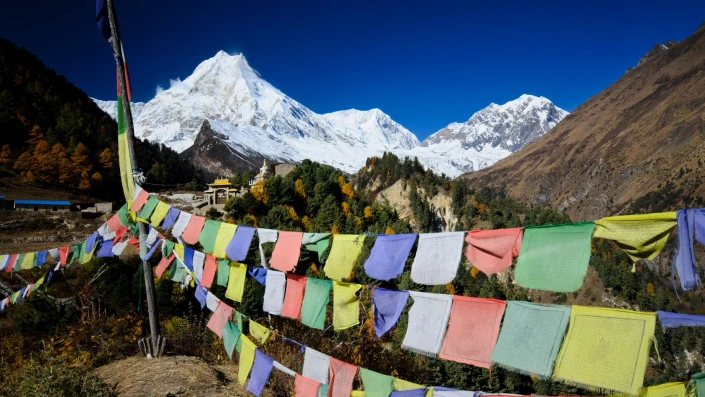
The Manaslu Circuit Trek is a trekking route that encircles Mount Manaslu (8,163 m / 26,781 ft) and passes through the Manaslu Conservation Area. Key features on the route include the rugged Nubri Valley, the turquoise Budi Gandaki River, the mesmerizing Larkya Pass, sacred Pungyen Gompa, deep blue Birendra Lake, and Buddhist villages along the trail. Trekkers describe the Manaslu trek as one of the most beautiful, pristine, less-commercialized, and serene treks in Nepal.
The itinerary starts in Kathmandu, and the walking part starts from Machha Khola. Common overnight villages on the route include Namrung, Sama Gaun, Samdo, and Bimthang. Larkya La is the highest point of the trek at 5,167 m (16,752 ft). From Larkya La, trekkers can see nearby peaks such as Himlung Himal (7,126 m / 23,379 ft), Annapurna II (7,937 m / 26,040 ft), Mount Manaslu (8,163 m / 26,781 ft), and Kang Guru (6,981 m / 22,903 ft).
Join our 13-day Manaslu Circuit Trek itinerary. The trail passes rocky cliffs, waterfalls, high mountains, glacial lakes, Buddhist villages, and monasteries. The trek includes close-range views of Mount Manaslu, Ngadi Chuli, Himalchuli, Siringi Himal, and Himlung Himal. The itinerary uses acclimatization planning and guide support to avoid altitude sickness during the trek.
Manaslu Circuit Trek Cost – 13 Days
The average cost of the trek is around USD 725 per person for the group of 3 to 5 trekkers.
USD 725 / person
| No. of people | Price per person |
|---|---|
| 2 Pax | USD 785 |
| 3 to 5 Pax | USD 725 |
| 6 to 9 Pax | USD 640 |
| 9 to 12 Pax | USD 615 |
Speak to An Expert
Cost Includes and Excludes
Cost Includes
- Pickup from Kathmandu Hotel in private vehicle
- Local tourist bus transfer Kathmandu to Machha Khola
- Local Jeep transfer Dharapani to Besisahar
- Local tourist bus transfer Besisahar to Kathmandu
- Accommodation in Twin-sharing Basis in Mountain Lodges
- Local English-Speaking Guide for 13 days
- Manaslu Conservation Area Permit
- Annapurna Conservation Area Permit
- Restricted Area Permit
- Rural Municipality Local Permit
- Trekking Map, Sun Hat, Duffel Bag
- Trip completion certificate
- Medical supplies (first aid kit will be available)
- Special Surprise Moment (disclosed only during the trek)
- Government Taxes
Cost Excludes
- Porter service for 13 days (optional – extra USD 230 per porter). One Porter can carry 2 trekkers load (24 kg)
- Meals (breakfast, lunch, and dinner) during the trek – around USD 15 Per Person
- Personal Expenses and Travel insurance, including high-altitude emergency evacuation coverage
- Tips for trekking staff and driver (expected)
- Hot showers, Wi-Fi usage, and battery charging
- International Payment Bank Charges
- Any expenses not mentioned in the Includes section
Why Our Trekking Packages Exclude Meals?
Travel To Nepal does not include meals in our standard trek packages to guarantee menu choice for trekkers. This is also true for Manaslu Circuit Trek. Fixed packages often limit trekkers to specific, pre-set meals. Meals-not-included policy allows trekkers to order based on their daily appetite and pay teahouse owners directly. Direct payments support the local economy while reducing food waste.
Policy Benefits and Logistics
- Dietary Flexibility: Trekkers select meals based on daily appetite and physical condition. This freedom allows hikers to adjust intake as digestion fluctuates with altitude changes.
- Direct Local Support: Cash payments go immediately to the families managing the lodges. This direct transaction supports the complex logistics of transporting ingredients via mules and porters.
- Cost Transparency: Daily food expenses average USD 15 per person. Prices correlate directly with elevation; menu costs increase at higher stops like High Camp and Badal Danda due to transport fees.
Manaslu Trek Itinerary 13 Days
Our 13-day Manaslu Circuit Trek itinerary follows the restricted Manaslu region in Nepal, including the Manaslu Conservation Area. The trip starts in Kathmandu with hotel pickup. The walking section starts at Machha Khola and follows the Budhi Gandaki River. Most trail days are in the Nubri Valley. Common villages on this route include Lho, Samagaon, Samdo, and Dharamsala (Larkya Phedi). The itinerary includes an optional hike to Manaslu Base Camp and Birendra Tal (Birendra Lake). Larkya Pass (Larkya La) is the highest point of the trek, reached on Day 11.
Day 1: Drive from Kathmandu city to Machha Khola Village
Day 1: Drive from Kathmandu city to Machha Khola Village
Highlights
- Scenic drive along the Trishuli River and Budi Gandaki River
- View of green terrace agricultural lands, small traditional villages, and towering rocky cliffs.
Kathmandu is the capital city of Nepal. Machha Khola is the starting point of our Manaslu Circuit Trek in Gorkha District. Machha Khola sits near the Budhi Gandaki River.
A local tourist bus to Machha Khola departs Kathmandu at 7:00 AM. Our vehicle picks you up from your hotel or another location inside Kathmandu and you meet your trek guide at the bus park. You board the tourist bus and drive on the Prithvi Highway, then take the Benighat diversion. Later sections of the route include gravel and dirt roads, with narrow bends. Trekkers often feel vibration and jolts on the unpaved sections. The lush valley views, terrace farming, and high rocky hills are mesmerizing today. After about 9 hours of driving, you reach Machha Khola and stay overnight. Dinner is around 7:00 PM. The guide briefs the next day’s plan after dinner. We recommend going to bed by 10:00 PM to get plenty of rest for the upcoming trek.
Day 2: Trek from Machha Khola to Jagat Village
Day 2: Trek from Machha Khola to Jagat Village
Highlights
- Tatopani: Refreshing natural hot springs along the trail.
- Budhi Gandaki: Dramatic cliffside walking, view of turquoise Budhi Gandaki below, and suspension bridge crossings.
- Khorlabeshi: Scenic Gurung village with coffee farms.
- Jagat Checkpoint: Entry to the Manaslu Conservation Area with stone-paved streets.
Machha Khola, Khorla Besi, Tatopani, Thulo Dhunga (Dovan), and Jagat are the main stops on Day 2 of the Manaslu Circuit trek.
Breakfast is at 7:00 A.M. at the Machha Khola teahouse. The walk from Machha Khola to Khorla Besi takes about an hour. The trail starts mostly flat and then turns uphill. Khorla Besi is a short break point for water and snacks.
The walk from Khorla Besi to Tatopani takes about 40 minutes. Tatopani is a natural hot spring beside the trekking route. The walk from Tatopani to Thulo Dhunga (Dovan) takes about 1-hour and 30-minute. Thulo Dhunga is a common lunch stop around midday. Typical lunch items include dal bhat and noodles, with drinks such as juice.
The walk from Thulo Dhunga to Jagat usually starts around 1:30 P.M. and takes about 3 hours, with long uphill sections. Many trekkers reach Jagat around 4:00 P.M. The route includes landslide-risk sections and slippery surfaces, and some parts may follow a road where vehicle dust is present. Daytime heat is common on the lower, tropical part of the trail. Jagat has 10 teahouses, mani walls, and stupas. Many rooms have attached bathrooms, and some rooms provide Wi‑Fi and charging sockets.
The dinner is at 7:00 PM. After a short brief by our guide for the Day 3 trek, trekkers normally sleep at around 10:00 PM.
Day 3: Trek from Jagat to Deng Village
Day 3: Trek from Jagat to Deng Village
Highlights
- Sirdibas Village: A traditional settlement offering the first strong glimpses of Tibetan-influenced culture and stone architecture.
- Philim Village: A large, prosperous Gurung village surrounded by terraced fields of maize and potatoes, home to a prominent Japanese-supported school.
- Ekvant Bhatti: A dramatic section of the trail where the path is carved directly into the steep cliffside above the river.
- Siringi Himal Views: Your first clear, impressive views of the snow-capped Siringi Himal (7,187 meter) as the valley opens up.
- Bamboo & Rhododendron Forests: A scenic transition into cooler, denser forests as you cross the river multiple times via high suspension bridges.
- Nyak Phedi: A quiet riverside stop that marks the final stretch before the final ascent into Deng.
Jagat, Salleri, Philim, Chisapani, and Deng are the main stops on Day 3 of the Manaslu Circuit Trek.
The hike starts around 8:00 A.M. after breakfast in Jagat. The trail follows the Budhi Gandaki riverbank and includes suspension bridges, mani walls, and stupas. The walk from Jagat to Salleri takes about 1 hour and 45 minutes. After about 25 minutes, the route passes a waterfall with a pond and a bridge. The walk from Salleri to Philim takes about 1 hour and includes a suspension bridge over the Budhi Gandaki.
The walk from Philim to Chisapani, a typical lunch stop, takes about 1 hour. The walk from Chisapani to Deng takes about 4 hours, has long uphill sections and the route also connects toward Tsum Valley. Deng is a small village on the riverbank with about 7 teahouses; rooms usually do not have attached bathrooms.
Dinner is usually served in a shared dining hall with a central heater at around 7:00 PM. Sleep is recommended not later than 10:00 PM.
Day 4: Trek from Deng to Namrung Village
Day 4: Trek from Deng to Namrung Village
Highlights
- Rana & Bihi Phedi: Traditional stone-built villages featuring the first major Mani walls (prayer-inscribed stones) of the trek.
- Ghap Village: A scenic stop known for its ancient mani stones and intricate wood carvings on local houses.
- First High Peaks: Your first clear views of Himalchuli (7,893 m), Manaslu North (7,157 m), and Naike Peak.
- Lush Forest Canopy: A long, beautiful stretch of trekking through dense forests of fir, rhododendron, and oak.
- Namrung Village: Arrival at a well-developed village with excellent viewpoints, famous for its unique local dialect and stone architecture.
Jagat, Salleri, Philim, Chisapani, and Deng are the main stops on Day 3 of the Manaslu Circuit Trek.
Deng to Namrung is a full trekking day on the Manaslu Circuit on Day 4.
The route uses the Budhi Gandaki valley and includes a major suspension-bridge crossing. Most groups leave Deng after breakfast and reach Namrung in mid‑afternoon, with several uphill sections.
The trail climbs first toward Bihi Phedi. Bihi Phedi is a small village with mani walls and gumbas. From Bihi Phedi, the path continues to Ghap in about 1 hour through an earthquake-affected section, so careful footing matters. Many trekkers stop in Ghap for lunch for about 1 hour.
After Ghap, the route reaches Namrung in about 2 hours. This section follows the Budhi Gandaki riverbank in parts and passes forest, waterfalls, and mani walls. Namrung has a gomba, a police post, and a small school. The village has about 4–5 teahouses with Wi‑Fi; rooms usually do not have attached bathrooms, and hot showers and Wi‑Fi may cost extra.
Day 5: Trek from Namrung to Shyala Village
Day 5: Trek from Namrung to Shyala Village
Highlights
- Lihi Village: A traditional settlement famous for its ancient chortens and terraced fields of barley and buckwheat.
- Lho Village: Home to the massive Ribung Monastery and a famous viewpoint for the iconic “Double Peak” of Mt. Manaslu (8,163 m).
- Glacier Views: Dramatic, close-up sights of the Pungyen Glacier and the massive icefalls of the Manaslu massif.
- Shyala’s 360° Panorama: Often considered the best viewpoint on the trek, offering unobstructed views of Himalchuli, Ngadi Chuli, and Manaslu.
- Tibetan Culture: Increasing presence of massive Mani walls, prayer wheels, and locals dressed in traditional Tibetan-style clothing (Chubas).
- Rhododendron & Pine Forests: A final stretch of high-altitude forest before transitioning into the alpine tundra near Samagaon.
Namrung, Sho, Lho, and Shyala are the main villages for the Day 5 on the Manaslu Circuit route.
The walk usually takes about 7 to 8 hours after breakfast in Namrung. The trail starts with about 30 minutes of flatter track and then shifts to long uphill sections with short downhill and narrow parts. Along the route you pass chortens, mani walls, prayer wheels, and prayer flags.
The section from Namrung to Sho takes about 2 hours on mostly flat ground. This part includes suspension bridges and open valley views. On clear stretches, Naike Peak can appear on the right side. The next section from Sho to Lho takes about 2 hours and brings the first consistent views of Manaslu and Himchuli.
After lunch at Lho, the trail continues toward Shyala with more uphill walking. The track passes pine, rhododendron, and juniper forest, with streams near the path in several places. Shyala has a central monastery, plus a stupa, mani walls, a school, and a health post. The village has about 50 houses and around 10 larger teahouses, with some homestays; some rooms provide Wi‑Fi and charging sockets.
As always, dinner is scheduled at 7:00 PM. Guide brief about the upcoming day after the meal and the sleep is at 10:00 PM.
Day 6: Trek from Shyala to Samagaon (Village)
Day 6: Trek from Shyala to Samagaon (Village)
Highlights
- Pungyen Glacier Moraine: A steady ascent across glacial debris and alpine meadows toward the massive south face of Manaslu.
- Pungyen Gompa (4,070 m): An ancient, secluded monastery situated on a vast highland plateau. It was famously destroyed by an avalanche in 1953 and later rebuilt.
- Up-Close Manaslu Views: Unrivaled, “front-row” perspectives of the Manaslu South Face and the hanging glaciers of Ngadi Chuli (Peak 29).
- High-Altitude Yak Pastures: Crossing the vast, flat plateaus where local herders graze yaks during the summer months.
Shyala, Pungyen Gompa, and Samagaun are the main places for the Day 6 on the Manaslu Circuit route.
The hike starts around 8:00 A.M. after breakfast in Shyala. The route to Pungyen Gompa uses a trail that differs from the standard Samagaun approach.
The walk from Shyala to Pungyen Gompa takes about 3 hour 30-minute. The first 2 hours are mostly uphill and include stone steps and a mountain path. After that, the trail has short flatter sections with gradual climbing before the monastery area. Near Pungyen Gompa, there is a water tap used for bottle refills, and the area includes open grassland and small streams.
The return walk follows the same route for about 1-hour 30-minute hours, then turns toward Samagaun. Many trekkers reach Samagaun at around 3:00 P.M. Samagaun functions as a local hub with an old monastery, a school, a check post, and a health post. The village has about 14 teahouses; many provide Wi‑Fi and charging, and some rooms have attached bathrooms.
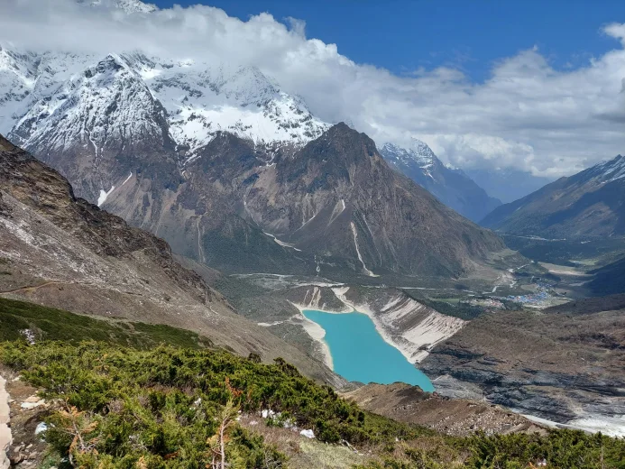
Day 7: Acclimatization Day. Hike to Manaslu Base Camp, or Birendra Tal
Day 7: Acclimatization Day. Hike to Manaslu Base Camp, or Birendra Tal
Highlights
- Glacial Lake: A stunning turquoise lake formed by the meltwater of the Manaslu Glacier.
- Icefall Views: Clear sights of the tumbling Manaslu icefalls and the rugged glacier moraine.
- Aerial Perspectives: Panoramic, “bird’s-eye” views of Samagaun village, Birendra Tal, and the surrounding Himalayan ranges.
- Alpine Tundra: Trekking through raw, high-altitude terrain with no facilities; a true wilderness experience at the foot of the world’s 8th highest peak.
Samagaun is the primary hub for high-altitude adaptation before the ascent to Samdo and Larkya La. Following the “climb high, sleep low” principle, trekkers choose from two main destinations based on their physical condition:
Birendra Tal (3,450 m): A 45-minute to 1-hour walk to a turquoise glacial lake at the base of the Manaslu Glacier. This is the low-intensity option, ideal for active recovery and conserving energy.
Manaslu Base Camp (4,800 m): An 8-hour difficult round trip. The trail gains approximately 1,200 meters of elevation over steep, rocky terrain. There are no teahouses or facilities above Samagaun; trekkers must carry adequate water and food. It provides a direct look at expedition operations and the upper glacier.
Day 8: Trek from Samagaon to Samdo Village
Day 8: Trek from Samagaon to Samdo Village
Highlights
- Ancient Mani Walls: Passing some of the longest and most intricately carved prayer-stone walls in the Manaslu region.
- Arid Alpine Tundra: A transition into a treeless landscape dominated by juniper bushes and wind-swept plateaus.
- Samdo Village: Staying in a traditional Tibetan refugee settlement, known for its yak herding culture and proximity to the Tibet border.
Day 8 follows the Manaslu Circuit route from Samagaun to Samdo. The walk starts after breakfast in Samagaun. The trail is mostly flat, with a mild uphill section near the end. The normal walking time is about 2–3 hours, and many groups eat lunch after arriving in Samdo.
Between Samagaun and Samdo, the path crosses alpine meadow terrain with no formal villages. You pass a few huts, mani walls, and small rivers. A wooden bridge over the Budhi Gandaki River comes before the final climb into Samdo.
Samdo is a mountain village with about 37 houses. The community is mainly Buddhist, and the village has monasteries and stupas. Samdo Peak and the Manaslu range are visible from the settlement in clear weather. Samdo has about 10 teahouses; some offer Wi‑Fi, charging access, and attached bathrooms, and hot showers may be available.
Day 9: Acclimatization Day: Hike to Rui La or Samdo Ri
Day 9: Acclimatization Day: Hike to Rui La or Samdo Ri
Highlights
- Historical Trade Route: You follow an ancient salt trade route that leads toward the Rui La Pass (4,998 m), which marks the border between Nepal and Tibet.
- The Summit Challenge: A steep, non-technical climb to the top of Samdo Ri (approx. 5,100 m), a ridge directly overlooking the village.
- Tibetan Plateau Views: From the high ridges, you get a rare and expansive look across the arid, brown landscape of the Tibetan Plateau stretching into the distance.
- 360-Degree Views: At the summit, you are rewarded with a full circle of peaks, including the Ganesh Himal range, Himlung Himal, Cheo Himal, and the towering mass of Manaslu.
Samdo is a common rest and second acclimatization stop on the Manaslu Circuit. This day adds one extra night in Samdo before higher terrain, including the approach toward Larkya La Pass. The plan is a return hike from Samdo and then sleep again in Samdo.
One option is a long day hike from Samdo to the Tibetan border pillar and back. The round-trip time is about 9 hours. The uphill section can take about 6 hours. The route crosses open alpine terrain and passes yak pastures, stone shelters, and prayer flags.
A shorter option is a hike from Samdo to Samdo Peak and back. The climb gains about 300–400 meters and takes about 2 hours. The trail stays on open alpine ground and ridge lines. This hike supports acclimatization for the next high-altitude stages of the Manaslu Circuit.
Day 10: Trek from Samdo to Dharmasala Settlement
Day 10: Trek from Samdo to Dharmasala Settlement
Highlights
- Larkya Bazaar: Passing the ruins of a once-thriving seasonal Tibetan market, where salt and grain were traded across the border for centuries.
- Barren Alpine Landscape: The scenery becomes stark and lunar-like, with the last of the vegetation disappearing as you enter the high-altitude desert zone.
- Crossing the Budhi Gandaki: One final crossing of the river (now just a small stream) near its glacial headwaters before leaving the valley floor.
- Larkya Glacier Views: A steady climb along the lateral moraine of the massive Larkya Glacier, offering a dramatic look at the ice and rock formations.
- Dharmasala (Larke Phedi): Arrival at the basic stone shelters that serve as the final “High Camp” before the pass. It is the highest sleeping point of the trek.
The Day 10 of Manaslu Circuit Trek starts at Samdo Village. Larke Bazaar is about a 30-minute walk from Samdo. Larke Bazaar is the only teahouse stop on this section. The route crosses a wooden bridge over the Budhi Gandaki River.
Larke Bazaar sits at a junction near the Tibetan border and the route to Dharamsala (Dharamshala). From Larke Bazaar, the trail goes about 500 meters uphill. The trail crosses another bridge and enters an alpine meadow area. The route has views of the Larkya Glacier. The day ends at a stone-built guesthouse in Dharamsala, with arrival around 2:00 pm.
Dharamsala is the most remote stop on this part of the trek. There is no village. There are about three hotels. Rooms are basic, and some people sleep in a common room on mats on a small wooden platform. Some trekkers do a short acclimatization walk to Khaki Danda (about 30 minutes). Dharamsala has no Wi‑Fi, no phone network, and no electricity. Charging is limited and depend on solar power.
Day 11: Trek from Dharmasala to Bimgthang Village. Cross Larkya La.
Day 11: Trek from Dharmasala to Bimgthang Village. Cross Larkya La.
Highlights
- Larkya La Summit (5,106 m): Reaching the highest point of the trek, marked by colorful prayer flags and a signpost, offering a profound sense of achievement.
- Massive Himalayan Views: A spectacular 360-degree panorama from the top, including Himlung Himal, Cheo Himal, Kang Guru, and the massive Annapurna II.
- Bhimthang Valley: Arrival at a wide, glacial valley surrounded by towering peaks. This area is often referred to as the “Plain of Sand” and is one of the most beautiful settings in the Himalayas.
- Sunset over Manaslu: Exceptional views of the west face of Mount Manaslu and Phungi Himal as the sun sets over the valley.
Day 11 on the Manaslu Circuit goes from Dharamsala to Larkya La Pass and ends at Bimthang. The day involves about 16 km of walking and more than 11 hours on steep, exposed terrain. We start early, around 4:00 AM, after our breakfast at 3:30 AM. The trail can be hazardous due to altitude, cold, and snow.
From Dharamsala to Larkya La Pass, the trail climbs soon after leaving camp. The first climb lasts about 20 minutes before the longer ascent continues. The route reaches Larkya La Pass at around 10:00 AM. From the pass, the route has views of Himlung Himal (7,126 m), Cheo Himal (6,820 m), Gyaji Kang (7,038 m), Kang Guru (6,981 m), and Annapurna II (7,937 m).
From Larkya La Pass to Larke Phedi, the trail descends for about 3 hours on snow and loose ground. Snow can hide the surface and make footing unstable. Larke Phedi has a few lodges where trekkers usually stop for lunch. The final descent from Larke Phedi to Bimthang takes about 2 hours, with rocky sections that increase slip risk. Bimthang has several teahouses, and some provide Wi‑Fi and charging sockets, but attached bathrooms are not available.
Day 12: Trek from Bimgthang to Dharapani Village
Day 12: Trek from Bimgthang to Dharapani Village
Highlights
- Dudh Khola Descent: The trail follows the banks of the “Milk River” (Dudh Khola), fed by the glaciers of the Manaslu massif.
- Subtropical Rainforests: A dramatic change in scenery as you descend through dense forests of rhododendron, oak, pine, and fir, which eventually give way to bamboo groves.
- Tilije Village: A culturally rich village known for its traditional architecture and for being one of the largest settlements of the Manang district in this area. It’s also famous for its local apple brandy.
The route runs from Bimthang to Dharapani on the exit side of the Manaslu Circuit. The section is a sustained descent toward Dharapani, which is the point where trekkers connect to the Annapurna Circuit trail and continue onward by foot or road transport.
Between Tilije and Dharapani, the trail uses established footpaths along the valley and includes suspension-bridge crossings over the Marsyangdi Khola. The same segment passes smaller settlements before reaching Dharapani, which functions as the trek’s main road-access exit point.
Day 13: Jeep Drive from Dharapani to Besisahar. Bus Drive to Kathmandu
Day 13: Jeep Drive from Dharapani to Besisahar. Bus Drive to Kathmandu
Highlights
- Marsyangdi River Valley: The jeep drive follows the turquoise Marsyangdi River, passing through the terraced hillsides of the Lamjung district.
Board a local jeep at Dharapani, navigating the Marsyangdi’s rugged, white-water gorge toward Besisahar. Swap jeep for a local bus in Besisahar, joining the rhythmic flow of the Prithvi Highway. Scenic terraced hills and roadside tea stalls blur past as you descend into the vibrant, urban sprawl of Kathmandu.
We will say goodbye, once we reach Kathmandu. We hope to see you again. If you would like to extend this tour with another trek, do short cultural tour of Kathmandu, or spend some leisure time on Chitwan, we would be more than happy to arrange it for you.
Manaslu Circuit Trek Map
Our local guides created this Manaslu Circuit Trek map to match our 13-day itinerary, as mentioned above. The map lists each village on the route and the planned overnight stops. It also shows the altitude for each village and names the mountain peaks visible along the trail.
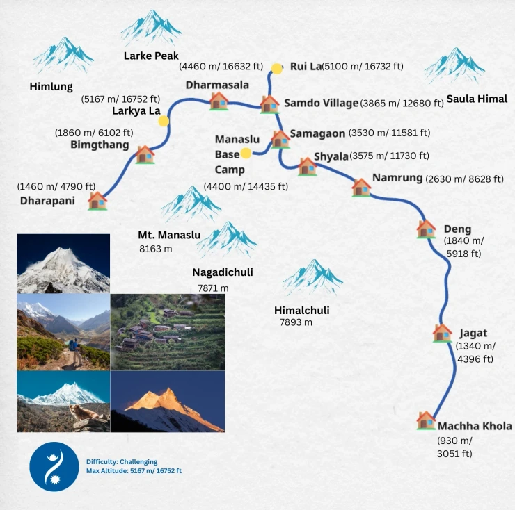
The Manaslu trek map labels these villages: Machha Khola, Jagat, Deng, Namrung, Shyala, Samagaon, Samdo, and Dharmasala. It lists the altitude for each village in meters and feet. It also names key peaks such as Mt. Manaslu, Nagadichuli, Himalchuli, and Himlung and marks the two passes: Larkya La and Rui La.
Table of Contents
Who is Manaslu Trek Suitable For?
The Manaslu Circuit Trek is suitable for trekkers who accept restricted-area rules, basic accommodation, long walking days, and high-altitude conditions. It fits trekkers with prior experience, adequate time in Nepal, interest in Mount Manaslu, Himalayan culture, wildlife, and low trail traffic.
- Solitude-Seeking Trekker: The Manaslu Circuit Trek suits trekkers who prefer lower trail traffic than the Everest Base Camp Trek and Langtang Trek. The route lies in a restricted area. Entry requires special permits, a licensed guide, and a minimum group size. These rules limit access and reduce foot traffic.
- Highest Mountain Trekker: The Manaslu Circuit Trek suits trekkers who want to see an 8,000-meter mountain. Mount Manaslu (8,163 m / 26,781 ft) is located in the same region. The route encircles Mount Manaslu, making it a constant reference point.
- Basic Comfort Trekker: The Manaslu Circuit Trek suits trekkers who accept basic teahouse accommodation. Lodges are family-run. Rooms have simple beds and shared bathrooms. At higher elevations, services such as charging, Wi-Fi, and hot showers are limited or inconsistent.
- Culture-Focused Trekker: The Manaslu Circuit Trek suits trekkers interested in Himalayan Buddhist culture. The trail passes villages with Tibetan Buddhist influence and monasteries. Local communities include Nubri (Nupri) and Gurung groups with distinct traditions.
- Nature-Loving Trekker: The Manaslu Conservation Area has wildlife such as snow leopard, musk deer, Himalayan tahr, and red panda. In spring, rhododendron forests bloom in lower elevations.
- Intermediate or Experienced Trekker: The Manaslu Circuit Trek suits trekkers with prior trekking experience. The route includes the Larkya La pass at 5,167 m. This crossing is physically demanding and not suitable for beginners.
- High-Endurance Trekker: Standard itineraries require 7 to 10 hours of walking per day. The trail includes steep ascents and a high-altitude pass. We can customize your itinerary by adding a number of days to reduce daily walking time.
- Time-Available Trekker: Trekkers should plan at least two weeks in Nepal for the Manaslu Circuit Trek. A 12-day itinerary is possible but increases altitude-related risk and is not advised.
- High-Altitude Trekker: The trek suits trekkers who are comfortable above 5,000 meters and with high-altitude pass crossings.
- No Solo Trekker: Solo trekking is not permitted in the Manaslu region. The area is restricted by the Government of Nepal. Foreign trekkers must hire a licensed guide, travel in a group of at least two, and book through a registered travel agency.
The Manaslu Circuit Trek is appropriate for experienced trekkers who can manage high altitude and long daily walks, and accept basic facilities. It is not suitable for solo trekkers, beginners, or travelers with limited time or low tolerance for physical and altitude-related demands.
Why Choose Travel To Nepal?
Special Moments
Our itineraries include cultural secrets and unrevealed activities to make your trek extra memorable.
Local Experts
Local guides from Sherpa, Tamang, Lama, Newar, and Chhetri communities lead every trek with deep local knowledge.
Seamless Service
Dedicated staff handle all permits and logistics to ensure a frictionless travel experience.
Active Guardianship
Our “Guarding the First Living Shangri-La” policy ensures that we protect our environment and local culture.
Custom Itineraries
We design personalized programs as per your preference, including arrangements for single guests.
Transparent Pricing
We have no hidden fees or forced add-ons included in our trek cost.
Frequently Asked Questions
Where does the Manaslu Circuit Trek start and end?
Our Manaslu Circuit trek package covers land transfer from/to Kathmandu. The trek starts at Machha Khola and ends at Dharapani in the Annapurna region.
How many days are required for the Manaslu Circuit Trek?
The standard Manaslu Circuit Trek takes 14 days, including acclimatization and overland transfers.
What is the maximum altitude reached on the Manaslu Circuit Trek?
The highest point is Larkya La Pass at 5,167 meters above sea level.
Is the Manaslu Circuit Trek suitable for beginners?
The trek is not suitable for beginners due to long walking days, high altitude, and a demanding mountain pass.
What permits are required for the Manaslu Circuit Trek?
Trekkers need a Manaslu Restricted Area Permit, Manaslu Conservation Area Permit, and Annapurna Conservation Area Permit.
Is a licensed guide mandatory for the Manaslu Circuit Trek?
Yes. A licensed trekking guide is mandatory under Nepal government regulations for restricted areas.
What is the minimum group size required for the Manaslu Circuit Trek?
A minimum of two trekkers is required, along with a local guide. Solo trekking is not permitted for foreigners.
What type of accommodation is available on the Manaslu Circuit Trek?
Accommodation consists of basic teahouses with simple rooms, shared bathrooms, and limited services at higher elevations.
What kind of food is available during the trek?
Teahouses provide simple meals such as rice, lentils, noodles, potatoes, eggs, and vegetables.
How difficult is the Manaslu Circuit Trek?
The trek is classified as challenging due to high altitude, rugged trails, and daily walking duration of about 7 to 10 hours.
What are the risks of altitude sickness on the Manaslu Circuit Trek?
Altitude sickness risk increases above 3,000 meters, particularly near Larkya La Pass, if acclimatization is inadequate. Our itinerary includes planned acclimatization days to reduce this risk. Travel To Nepal licensed trekking guide monitors trekkers daily and provides guidance based on observed symptoms and altitude conditions.
What is the highest pass point on the Manaslu Circuit Trek?
The highest point/pass is Larkya La, located at 5,167 meters.
Are ATMs available on the Manaslu Circuit Trek route?
ATMs are not available along the trekking route. Trekkers must carry sufficient cash from Kathmandu.
Is mobile network or internet access available during the trek?
Mobile networks are available in some villages. NTC SIMs are preferred for this region as NCELL SIMs do not work in remote areas. Internet access is limited and often unreliable in the Manaslu region.
What is the average cost of meals in the Manaslu trek?
The average cost of meals on the Manaslu Circuit Trek is around USD 15 per meal. Prices vary by village and increase at higher elevations due to transportation and supply constraints.