Popular and Classic Treks of Nepal
Classic treks in Nepal consist of established routes connecting major trails to high-altitude destinations like Everest Base Camp and the Annapurna Circuit. These routes feature developed infrastructure where local entrepreneurs operate lodges, restaurants, and shops. Trekkers use these paths to access 8,000-meter peaks, cross high mountain passes, and navigate protected conservation areas.
Everest Base Camp Trek 14 Days
Most Iconic Trek

Annapurna Circuit Trek 13 Days
Circle The Deadliest Peak

Ghorepani Poon Hill Trek 4 Days
Rhododendron Forest Trail
Langtang Trek 8 Days
Most Beautiful Trek
Table of Contents
Defining Characteristics of Classic Routes
Classic trekking routes feature established teahouse infrastructure with private lodging and standardized dining facilities. Local organizations, including the Sagarmatha National Park (SNP) and Annapurna Conservation Area Project (ACAP), regulate trail maintenance and waste management. Transportation hubs like Lukla Airport and Pokhara connect urban areas directly to major trailheads. Constant trekkers and accessible helicopter evacuation services ensure safety protocols along these paths.
Infrastructure Standards
Teahouse trekking relies on permanent lodges rather than camping equipment. Lodge owners provide private rooms with twin beds, mattresses, and blankets. Communal dining halls contain central heating stoves fuelled by yak dung or wood. Facilities include Western-style flush toilets and gas-powered hot showers. This infrastructure eliminates the need for trekkers to carry tents, food supplies, or cooking fuel.
Trail Management
Local organizations oversee trail maintenance and safety standards. The Sagarmatha Pollution Control Committee (SPCC) manages waste and route construction in the Khumbu region. The Annapurna Conservation Area Project (ACAP) maintains trails in the Annapurna sector. These organizations and local communities install stone steps, build steel suspension bridges over rivers, and place directional signage at junctions to guide hikers.
Accessibility and Logistics
Classic treks originate near established transportation hubs. Lukla Airport (Tenzing-Hillary Airport) serves as the primary entry point for the Everest region. Pokhara Airport connects travelers to the Annapurna region. Road networks link Kathmandu to specific trailheads, such as Besisahar for the Annapurna Circuit and Syabrubesi for the Langtang Valley.
Safety Protocols
These routes support a high volume of daily trekker traffic. This density ensures constant social support and clear path visibility. Local trekking agencies provide porter services to transport luggage between lodges. Helicopter companies operate rescue flights from designated helipads near major settlements for medical evacuations.
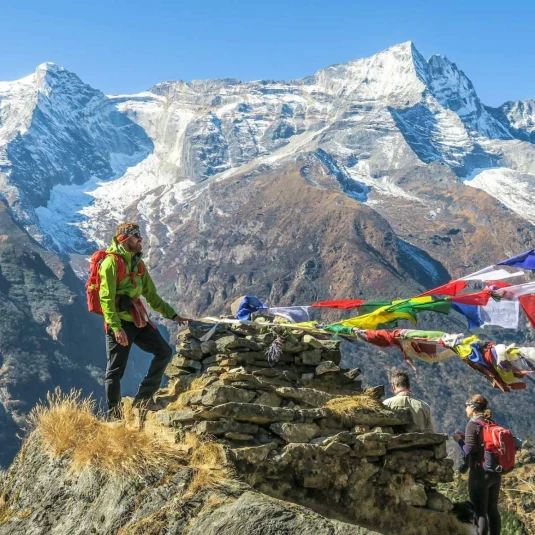
Everest Base Camp Trek
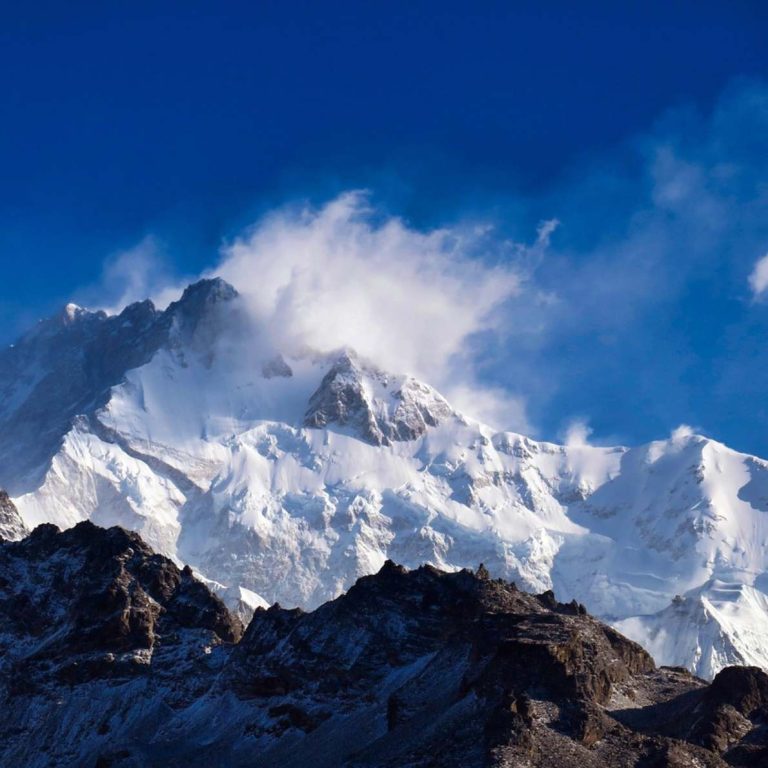
The Everest Base Camp (EBC) Trek functions as the definitive classic route in the Himalayas due to its established infrastructure and direct proximity to 8,000-meter peaks. This itinerary ranks as the most popular trekking choice in Nepal because it allows non-technical trekkers to reach the base of Mount Everest (8,848m) using a standardized network of teahouses. This is a total 130-kilometer round-trip journey. The route combines high-altitude trekking with established Sherpa hospitality infrastructure.
Key Settlements
- Lukla (2,860m): Lukla functions as the logistical hub and primary trailhead. It houses the Tenzing-Hillary Airport, local airline offices, and the Pasang Lhamu Nicole Niquille Hospital.
- Phakding (2,610m): This village serves as the standard first-night stop. Its lower elevation relative to Lukla aids the initial acclimatization process.
- Namche Bazaar (3,440m): Namche serves as the first recommended acclimatization stop and operates as the commercial and administrative capital of the Khumbu region. The town layout resembles a horseshoe amphitheater and hosts the weekly Saturday market.
- Tengboche (3,860m): This settlement centers around the Tengboche Monastery, the largest Gompa in the Khumbu region. Trekkers observe the Mani Rimdu festival here during autumn.
- Dingboche (4,410m): Dingboche serves as the second recommended acclimatization stop. Stone walls surround the village fields to protect barley crops from cold winds.
- Lobuche (4,940m): This cluster of lodges sits adjacent to the Khumbu Glacier. It marks the transition into the high-altitude rocky desert zone.
- Gorakshep (5,164m): Gorakshep acts as the final village before reaching Everest Base Camp and Kala Patthar. Once a vast summer grazing pasture, this small settlement is the highest permanently inhabited place of the EBC trek.
Trail Difficulty and Terrain Specifications
The route demands consistent physical endurance. Trekkers walk an average of 5 to 7 hours daily. The trail involves cumulative elevation gains and losses exceeding 4,500 meters.
- Surface Conditions: The path consists of dirt tracks, stone staircases, and loose scree. The section approaching Everest Base Camp requires navigating the rocks of the Khumbu Glacier.
- Steep Ascents: The climb from Jorsalle to Namche Bazaar involves an 800-meter vertical gain. The ascent of the Thuk La, between Pheriche and Lobuche, requires a steep climb past memorial chortens dedicated to deceased climbers.
- Altitude Factors: Oxygen levels at Base Camp drop to approximately 50% of sea level values. This reduction increases the risk of Acute Mountain Sickness (AMS), necessitating structured acclimatization rest days at Namche and Dingboche.
Accommodation and Infrastructure Standards
The Everest region possesses the most advanced trekking infrastructure in the Himalayas.
- Lodging: Teahouses provide private twin rooms with foam mattresses and blankets. Dining halls feature central stoves fuelled by dried yak dung.
- Connectivity: Everest Link provides prepaid Wi-Fi cards with coverage extending to Gorakshep. Ncell and Nepal Telecom offer 4G cellular service in lower sections like Namche and Tengboche.
- Hygiene: Lower altitude lodges offer gas-powered hot showers and Western flush toilets. Above Dingboche, facilities typically transition to bucket showers and squat toilets to prevent plumbing freezing.
- Power: Bedrooms in premium lodges contain charging outlets. Standard lodges offer charging stations in the communal dining area, often for an hourly fee.
Who is this trek right for?
- Goal-Oriented Travelers: Hikers intending to stand at the base of Mount Everest (8,848m) choose this route to their “bucket-list” objectives.
- Fit Novice Trekkers: Beginners with good cardiovascular fitness manage the high-altitude terrain by adhering to structured acclimatization itineraries.
- Amenities-Focused Visitors: Travelers requiring modern sanitation select this trek for its consistent access to gas-powered hot showers, Western-style flush toilets, and diverse food menus that accommodate dietary restrictions.
- Safety-Prioritizing Groups: Solo travelers and groups prioritize this classic route because the high volume of daily traffic (trekkers) ensures readily available assistance.
Annapurna Circuit Trek
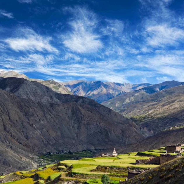
The Annapurna Circuit Trek functions as a definitive classic route because it is one of the first few popular treks of Nepal. It circumnavigates the Annapurna Massif (8,091m). This 160 to 230-kilometer loop ranks as a popular itinerary due to its geological diversity, connecting the subtropical forests of the Marsyangdi Valley with the rain-shadow desert of the Manang and Mustang districts. The crossing of Thorong La Pass (5,416m) serves as the route’s central physical objective, allowing non-technical trekkers to experience high-altitude mountaineering conditions.
Key Settlements and Route Milestones
- Besisahar (760m): Besisahar serves as the district headquarters of Lamjung and the traditional starting point of the circuit.
- Chame (2,670m): This administrative center of the Manang District features hot springs and views of Lamjung Himal.
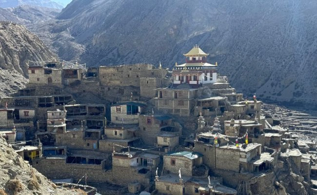
- Manang (3,519m): Manang sits beneath the Gangapurna Glacier and Annapurna III (7,555m). It marks the transition from the humid Marsyangdi valley to the arid trans-Himalayan plateau. Trekkers use this location to acclimatize by hiking to high-altitude points like Praken Gompa or the Ice Lake (4,600m)
- Thorong Phedi (4,450m): This settlement serves as the final resting point before crossing Thorang La.
- Muktinath (3,760m): Muktinath hosts a sacred temple complex revered by both Hindus and Buddhists. The site features 108 stone water spouts and an eternal natural gas flame.
- Jomsom (2,720m): Jomsom acts as the administrative capital of the Mustang District. It houses Jomsom Airport, which connects the region to Pokhara.
- Marpha (2,650m): This village is the center of apple production in Nepal. It is defined by its white-washed stone houses and drainage systems built beneath the flagstone streets.
Trail Difficulty and Terrain Specifications
The trek requires 13 days to complete depending on transportation choices.
- Geological Transition: Hikers start in humid, green valleys with terraced rice paddies. Beyond Pisang (3,200m), the landscape shifts to a dry, high-altitude desert with minimal vegetation.
- The Pass Crossing: The ascent of Thorong La (5,416m) is the route’s physically challenging part. Trekkers typically depart Thorong Phedi at 4:00 AM to avoid high winds. The subsequent descent to Muktinath involves a 1,600-meter vertical drop in a single day.
- Surface Conditions: The trail includes dirt paths, rocky riverbeds, and sections of jeep track. The New Annapurna Trekking Trail (NATT) initiative has marked alternative footpaths to avoid vehicular roads.
Accommodation and Infrastructure Standards
The Annapurna Circuit features a continuous chain of standardized teahouses established by local entrepreneurs.
- Lodging: Lodges in Manang and Mustang often feature attached bathrooms and gas-powered hot showers. The architecture in the Kali Gandaki valley reflects Thakali traditions with flat roofs and enclosed courtyards.
- Road Accessibility: Jeep roads now extend from Besisahar to Khangsar and from Muktinath to Pokhara. This infrastructure allows trekkers to skip lower elevation segments or exit the region quickly if necessary.
- Connectivity: 3G and 4G mobile data (Ncell/Nepal Telecom) function in major towns like Chame, Manang, and Jomsom. Wi-Fi is available in most lodges.
- Food Supply: The region produces apples, buckwheat, and vegetables locally. Menus include apple pie, apple brandy, and buckwheat bread alongside standard trekking fare.
Who is this trek right for?
- Goal-Oriented Travelers: Hikers aiming to cross a high mountain pass (5,416m) choose this route to test their endurance and complete a full circumnavigation of a massif.
- Landscape Enthusiasts: Visitors prioritize this trek to experience the drastic geological shift from subtropical jungle to high-altitude desert within a single journey.
- Flexible Itinerary Planners: Hikers with time constraints use the road network to shorten the trek by driving to Chame or flying out of Jomsom.
- Amenities-Focused Visitors: Travelers prefer this circuit for its developed infrastructure, including extensive menu options and the availability of private rooms throughout the route.
Ghorepani Poon Hill Trek
The Ghorepani Poon Hill Trek is a popular beginner-friendly trek within the Annapurna Conservation Area. This trek has established Magar villages, modern facilities, and teahouse infrastructure. The ascent to Poon Hill (3,210m) provides spectacular sight of the Dhaulagiri and Annapurna massif. The trail passes through the world’s largest dense rhododendron forests, specifically within the section between Ghorepani and Tadapani.
Key Settlements and Route Milestones
- Nayapul (1,070m): Nayapul is a small village where Ghorepani Poon Hill trek starts. It connects to Pokhara via a 1.5-hour drive along the Baglung Highway.
- Tikhedhunga (1,540m): This settlement sits on the banks of the Bhurungdi Khola. It marks the base of the steep ascent to Ulleri.
- Ulleri (1,960m): Ulleri is a Magar village defined by its stone architecture. Trekkers reach this location by climbing a stone staircase consisting of approximately 3,300 steps.
- Ghorepani (2,874m): This village serves as the main staging area for the Poon Hill excursion. The settlement is divided into Lower Ghorepani and Upper Ghorepani. Historically, it functioned as a watering stop for trader mule caravans.
- Poon Hill (3,210m): Poon Hill is the highest elevation point of the trek. It features a viewing tower that overlooks 15 peaks, including Dhaulagiri I, Annapurna South, and Machhapuchhre.
- Tadapani (2,630m): This settlement sits on a ridge surrounded by rhododendron and oak forests. It serves as a junction point connecting the route to Ghandruk or the upper Khopra Ridge.
- Ghandruk (1,940m): Ghandruk is the second-largest Gurung village in Nepal. It houses the ACAP headquarters and the Old Gurung Museum. The village preserves traditional slate-roofed housing and agricultural terraces.
Trail Difficulty and Terrain Specifications
The trek requires 4 days to complete depending on the starting point (Pokhara).
- Geological Context: The trail remains within the sub-alpine zone. Unlike the Annapurna Circuit, it does not cross the snow line or high-altitude passes. Therefore, the risk of altitude sickness is low.
- The Stone Steps: The section between Tikhedhunga and Ulleri presents the route’s primary physical challenge. This segment consists of a continuous vertical ascent on paved stone steps.
- Surface Conditions: The trail is well-defined and predominantly paved with stone slabs. Dirt paths connect Tadapani to Ghandruk. The route remains accessible throughout the year, though winter snow may cover the path near Poon Hill.
- Vegetation Zones: The lower trail passes through terraced rice and millet fields. Above 2,200 meters, the landscape transitions into dense forests of Rhododendron arboreum, oak, and bamboo.
Accommodation and Infrastructure Standards
The Ghorepani Poon Hill Trek features a high density of established teahouses and lodges.
- Lodging: Lodges in Ghorepani and Ghandruk offer private rooms, attached bathrooms, and gas-powered hot showers. Many dining halls feature central heating stoves.
- Connectivity: 4G mobile data (Ncell/Nepal Telecom) functions across 90% of the trail. Most lodges provide Wi-Fi access for a fee.
- Road Accessibility: Jeep roads now extend to Ghorepani and to Ghandruk. This infrastructure allows trekkers to shorten the walking duration significantly.
- Food Supply: The region relies on local agriculture and transport from Pokhara. Menus satisfy international standards, offering pizza, pasta, and bakery items alongside traditional Nepali Dal Bhat.
Who is this trek right for?
- Time-Constrained Travelers: Visitors choose this route to view 8,000-meter peaks within a 4-day itinerary without requiring domestic flights.
- Beginner Trekkers: Hikers select this trek due to its lower maximum altitude (3,210m), which significantly reduces the risk of Acute Mountain Sickness (AMS).
- Cultural Observers: Travelers prioritize this route to observe the distinct culture, architecture, and museums of the Magar and Gurung ethnic groups in Ulleri and Ghandruk.
- Winter Trekkers: Trekkers can use this trail during the winter months (December–February) when higher altitude passes like Thorong La are inaccessible due to snow.
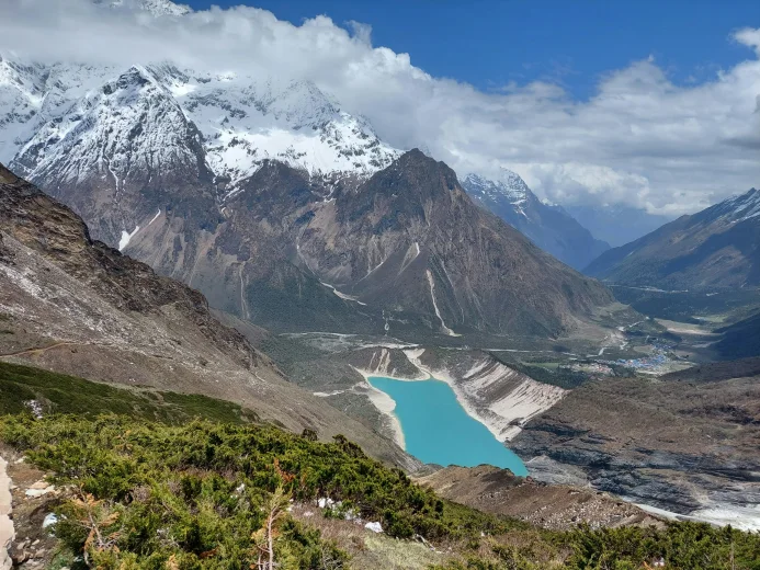
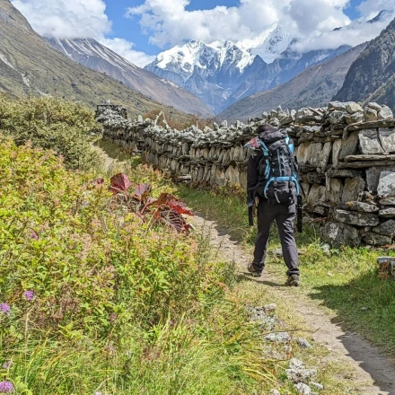
Langtang Valley Trek
The Langtang Valley Trek is the nearest major trekking destination to Kathmandu, allowing trekkers to reach the starting point, Syabrubesi, within a 6-hour drive. The trek is popular for its scenery of the Langtang range, subtropical forests, and frequent sightings of red pandas. The route can be completed within 8 days, and the accommodation and dining facilities are among the most well-maintained among the trekking regions of Nepal.
Key Settlements and Route Milestones
- Syabrubesi (1,550m): Syabrubesi functions as the primary trailhead and logistical hub. It connects to Kathmandu via a 6-hour drive along the Pasang Lhamu Highway.
- Lama Hotel (2,470m): This cluster of teahouses sits within a dense forest of oak, maple, and rhododendron. It serves as a standard overnight stop due to the steep elevation gain required to reach the upper valley.
- Langtang Village (3,430m): This settlement is the administrative and cultural center of the valley. A massive avalanche destroyed the original village during the April 2015 earthquake. The current settlement sits 100 meters east of the memorial chortens and debris field.
- Mundu (3,543m): Mundu features traditional stone houses with wooden carved windows. It serves as an alternative stop to Langtang Village for better acclimatization.
- Kyanjin Gompa (3,870m): Kyanjin Gompa acts as the final destination and acclimatization base before climbing Tserko Ri (4,985m). It houses a centuries-old Buddhist monastery and a government-operated yak cheese factory established in 1955.
Trail Difficulty and Terrain Specifications
The trek requires 8 days to complete.
- Geological Profile: The valley is a U-shaped glacial valley. The trail ascends gradually alongside the river, avoiding the steep passes found in the Annapurna or Everest regions.
- High Point Objectives: While the highest settlement of the trek is Kyanjin Gompa (3,870m), optional day hikes to Tserko Ri (4,985m) or Kyanjin Ri (4,773m) takes trekkers to near-5,000-meter altitudes.
- Vegetation Zones: The lower section (Syabrubesi to Ghoda Tabela) passes through Langtang National Park forests inhabited by red pandas and Himalayan black bears. The upper valley (above 3,000m) consists of open yak pastures and scrub vegetation.
- Surface Conditions: The trail was reconstructed after 2015. It consists of stone steps, dirt paths, and suspension bridges crossing the Langtang Khola.
Accommodation and Infrastructure Standards
The region features newly constructed teahouses following the post-earthquake reconstruction efforts.
- Lodging: New structures utilize concrete and stone with insulated dining halls. Rooms are typically twin-share with common bathrooms, though attached bathrooms are available in Syabrubesi and Kyanjin Gompa.
- Connectivity: Nepal Telecom (NTC) provides 3G/4G coverage in Syabrubesi and intermittently in Kyanjin Gompa. Ncell signal is not available in the upper valley. Wi-Fi is available in most lodges via Everest Link or satellite services.
- Food Supply: The valley is known for yak dairy products. The cheese factory in Kyanjin supplies fresh yak cheese. Menus include both international cuisine and Tibetan specialties like Thukpa and Syakpa (Sherpa stew).
- Accessibility: The starting point is accessible solely by road. Public buses and private jeeps operate daily from Kathmandu’s Machhapokhari bus park.
Who is this trek right for?
- Budget-Conscious Travelers: Hikers choose this route to eliminate the cost and weather uncertainty of domestic flights to Lukla or Jomsom.
- Cultural Visitors: Travelers prioritize this trek to observe the Tamang and Hyolmo cultures, which share linguistic and religious roots with Tibet.
- Short-Duration Trekkers: Visitors with limited schedules select this itinerary to reach high-altitude Himalaya region within 8 days.