In this guide (9 sections)
What the Annapurna Circuit Map Shows?
The Annapurna Circuit trek map shows a route that curves around the north side of the Annapurna mountains. It climbs up the Marsyangdi valley from Besisahar, crosses Thorong La Pass at 5,416 m, and comes down the Kali Gandaki valley to Muktinath and Jomsom.
On the map, you drive from Kathmandu to Besisahar and Chame, then walk about 100 km over 8 days. The walking route passes Upper Pisang, Ngawal, Manang, Tilicho Lake, Yak Kharka and Thorong Phedi before the pass. The highest place you sleep is Thorong Phedi at 4,450 m, and the road takes you back from Muktinath to Pokhara and Kathmandu.
This page gives you the map of Annapurna Circuit Trek in three formats: a map image, an interactive Google Map and a downloadable PDF. Below the maps, you'll find a day-by-day table with distances and altitudes, the elevation profile, side trips, other route options and current trail conditions.
Interactive Google Map of the Annapurna Circuit
Annapurna Circuit MapLoading it connects to Google, which can see your IP address and may set cookies.
The interactive Google Map lets you zoom in on every village, viewpoint and road section on the route. It has separate layers that you can turn on and off:
Walking route: Chame to Muktinath, including the Tilicho Lake detour
Jeep roads: Besisahar to Chame, and Muktinath to Beni
Overnight villages: all 13 stops with their altitudes
Landmarks: Thorong La, Ice Lake, Tilicho Lake, Jomsom.
Note: The map is only for planning purpose.
Annapurna Circuit Map Image
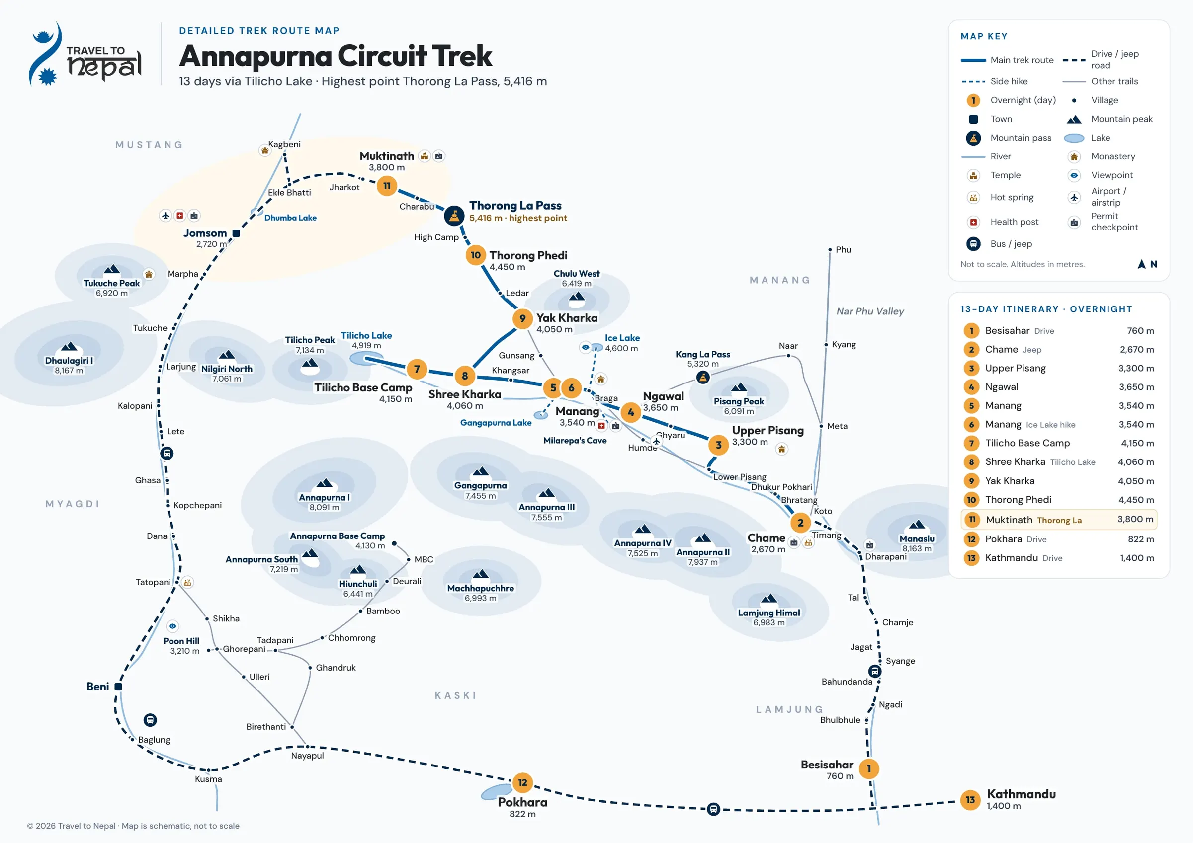
Image: Complete Annapurna Circuit Trek Map
The map image shows the full 13 day route with a numbered circle at each overnight stop. Number 1 is Besisahar (760 m), number 2 is Chame (2,670 m), and the numbers continue through Upper Pisang, Ngawal, Manang, Tilicho Base Camp, Shree Kharka, Yak Kharka and Thorong Phedi. Thorong La Pass is marked as the highest point of the trek at 5,416 m. After the pass, the route drops to Muktinath (3,800 m) and returns by road to Pokhara and Kathmandu.
The map is schematic, which means it is not drawn to scale. Two villages that look close on the map can still be a full day of walking apart. Use the itinerary table further down this page for real distances and walking hours.
Annapurna circuit trek with Tilicho lake map
Map of Annapurna Circuit trail with tilicho lake
Annapurna Circuit Elevation Profile
How to Read the Map Key
The map key explains what each line, number and symbol on the map means. Lines show how you travel:
Main trek route: the trail you walk each day
Drive / jeep road: sections you cover by bus or jeep
Side hike: day hikes, such as Ice Lake from Manang
Other trails: nearby treks that connect to the circuit
The numbered circles match the days in the itinerary. Manang shows two numbers (5 and 6) because you sleep there two nights for acclimatization. Other symbols mark villages, towns, mountain peaks, passes, lakes, rivers, monasteries, temples and viewpoints.
Service symbols help you plan practical stops. They show the hot spring at Tatopani, the airport at Jomsom, health posts, permit checkpoints and bus or jeep stops. All altitudes on the map are in metres, and the north arrow sits in the corner.
Mountains, Valleys and Districts on the Map
The Annapurna Circuit goes around the Annapurna massif, so the map shows many of Nepal's best-known peaks:
Annapurna range: Annapurna I (8,091 m), Annapurna II (7,937 m), Annapurna III (7,555 m), Annapurna IV (7,525 m) and Gangapurna (7,455 m)
Around Manang: Tilicho Peak (7,134 m), Pisang Peak (6,091 m) and Chulu West (6,419 m)
Above the Kali Gandaki: Dhaulagiri I (8,167 m), Tukuche Peak (6,920 m) and Nilgiri North (7,061 m)
Further away: Manaslu (8,163 m) to the east, and Machhapuchhre (6,993 m), Annapurna South (7,219 m), Hiunchuli (6,441 m) and Lamjung Himal (6,983 m) to the south
The route links two big river valleys. The Marsyangdi valley takes you up from Besisahar to Manang. Thorong La connects it to the Kali Gandaki valley, which takes you down through Mustang to Beni.
The trek passes through five districts. You start in Lamjung (Besisahar), walk through Manang (Chame to Thorong La), cross into Mustang (Muktinath, Jomsom and Marpha), and drive through Myagdi (Tatopani and Beni) to Kaski (Pokhara). The people change with the land, too: Gurung villages in the lower Marsyangdi, Manangi and Tibetan Buddhist culture in upper Manang, and Thakali villages in the Kali Gandaki.
Annapurna Circuit Route Overview
The Annapurna Circuit trek is a 13 day teahouse trek that starts and ends in Kathmandu, with about 100 km of walking between Chame and Muktinath. Here are the key route facts in one place:
Route fact | Detail |
|---|---|
Start and end | Kathmandu (1,400 m) |
Trek starts | Chame (2,670 m), reached by bus and jeep |
Trek ends | Muktinath (3,800 m), then by road to Pokhara |
Total days | 13 days, including 1 acclimatization day in Manang |
Walking distance | About 100 km (62 miles) over 8 walking days |
Walking time | About 47–49 hours, plus 6 to 8 hours for the Ice Lake hike |
Highest point | Thorong La Pass, 5,416 m (17,769 ft) |
Highest sleeping place | Thorong Phedi, 4,450 m (14,600 ft) |
Accommodation | Teahouses (local lodges) every night |
Permit | Annapurna Conservation Area Permit (ACAP) |
Best months | March, April, October and November |
Which Direction to Walk the Circuit
Most trekkers walk the Annapurna Circuit counterclockwise, from the Marsyangdi valley in the east to the Kali Gandaki valley in the west. This direction lets your body get used to the altitude slowly. You sleep at Chame (2,670 m), Upper Pisang (3,300 m), Ngawal (3,650 m) and Manang (3,540 m) before you go higher.
The climb to Thorong La is also much shorter from this side. From Thorong Phedi (4,450 m), you gain about 966 m to reach the pass. If you walk the other way, you start the pass day at Muktinath (3,800 m) and must climb about 1,616 m in one go, with less time to acclimatize.
This is why our itinerary, and most teahouse lodges and trail services, follow the counterclockwise direction.
Road Sections and Walking Sections
The Annapurna Circuit is part road and part trail, so you drive at the start and end and walk in the high middle section. Roads now reach both sides of the circuit:
East side (drive): Kathmandu to Besisahar by tourist bus (176 km, about 7 hours), then by jeep up the Marsyangdi valley to Chame (about 65 km, 5–6 hours)
Middle (walk): Chame to Muktinath on foot, including the Tilicho Lake detour and Thorong La Pass
West side (drive): Muktinath to Pokhara by jeep and bus via Jomsom and Beni (about 183 km, 7 hours), then Pokhara to Kathmandu (200 km, about 7 hours)
In some places, the walking trail runs close to the road. Between Chame and Bhratang, you share part of the route with the road, which was damaged in October 2026 but stays open for walkers. Above Upper Pisang, the upper route via Ghyaru and Ngawal has no road at all.
Annapurna Circuit Itinerary Map: Distance, Time and Altitude
The 13 day Annapurna Circuit itinerary has 2 road days at the start, 8 walking days, 1 acclimatization day and 2 road days at the end. This table shows where you sleep, how high you go, and how far you travel each day:
Day | Route | Highest point | Travel | Distance |
|---|---|---|---|---|
1 | Kathmandu → Besisahar | 1,400 m | Drive 7 h | 176 km (109 mi) |
2 | Besisahar → Chame | 2,670 m | Jeep 5 to 6 h | 65 km (40 mi) |
3 | Chame → Upper Pisang | 3,300 m | Walk 5 to 6 h | 14 km (8.7 mi) |
4 | Upper Pisang → Ngawal | 3,730 m | Walk 4 to 5 h | 10 km (6.2 mi) |
5 | Ngawal → Manang | 3,650 m | Walk 4 h | 10 km (6.2 mi) |
6 | Ice Lake hike from Manang | 4,600 m | Walk 6 to 8 h | Day hike |
7 | Manang → Tilicho Base Camp | 4,150 m | Walk 7 h | 15 km (9.3 mi) |
8 | Tilicho Base Camp → Tilicho Lake → Shree Kharka | 4,919 m | Walk 7 h | 15 km (9.3 mi) |
9 | Shree Kharka → Yak Kharka | 4,060 m | Walk 7 h | 13 km (8.1 mi) |
10 | Yak Kharka → Thorong Phedi | 4,450 m | Walk 4 h | 7 km (4.3 mi) |
11 | Thorong Phedi → Thorong La → Muktinath | 5,416 m | Walk 9 h | 16.2 km (10.1 mi) |
12 | Muktinath → Pokhara | 3,800 m | Drive 7 h | 183 km (114 mi) |
13 | Pokhara → Kathmandu | 1,400 m | Drive 7 h | 200 km (124 mi) |
Walking times include short rests but not long lunch breaks. Your own pace, the weather and trail conditions can change these times by an hour or more.
Side Trips and Acclimatization Hikes Near Manang
The best side trips on the Annapurna Circuit start from Manang and Braga, and they help your body adjust to the altitude before Tilicho Lake and Thorong La. The rule is simple: hike high during the day, then sleep low. On our itinerary, Day 6 in Manang is set aside for one of these hikes, usually Ice Lake.
Side hike | Top altitude | Time | Difficulty |
|---|---|---|---|
Ice Lake (Kicho Tal) from Manang | 4,600 m (+1,060 m) | 6 to 8 h return | Hard: steep all the way |
Praken Gompa from Manang | 3,945 m (+405 m) | About 2 h up | Moderate |
Chongkor Viewpoint from Manang | 3,900 m | 1 to 2 h return | Easy to moderate |
Gangapurna Lake from Manang | Just above Manang | About 30 min | Easy |
Milarepa's Cave from Braga | 4,100 m | About 2 h each way (about 5 km) | Moderate, steep |
Ice Lake is the best choice if you feel well and want the strongest acclimatization. It gains more than 1,000 m and gives the widest views of the Annapurna range. Praken Gompa and Chongkor Viewpoint are good options for a shorter, easier day. Gangapurna Lake is so close to Manang that you can visit it on the afternoon you arrive.
Milarepa's Cave is linked to the Tibetan poet and yogi Milarepa, who is said to have meditated here. Tilicho Lake is part of our main itinerary on Day 8, so it is covered in the route section above.
Plan Your Route With the Map
The Annapurna Circuit map shows a simple shape: up the Marsyangdi valley, over Thorong La at 5,416 m, and down the Kali Gandaki valley. The hard part is in the middle, between Manang and Muktinath, where you walk at around 4,000 m for several days and cross the pass on the longest day of the trek.
Use the map image to understand the route, the interactive Google Map to check villages and side hikes, and the PDF map as your backup on the trail. Before you go, decide whether you want the Tilicho Lake detour, keep 2–3 spare days for snow or landslides, and check the latest road and pass conditions.
Was this guide helpful?
Want our trekking guides to show up first when you search on Google?